
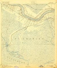
~ Hahnville LA topo map, 1:62500 scale, 15 X 15 Minute, Historical, 1891, updated 1921
Hahnville, Louisiana, USGS topographic map dated 1891.
Includes geographic coordinates (latitude and longitude). This topographic map is suitable for hiking, camping, and exploring, or framing it as a wall map.
Printed on-demand using high resolution imagery, on heavy weight and acid free paper, or alternatively on a variety of synthetic materials.
Topos available on paper, Waterproof, Poly, or Tyvek. Usually shipping rolled, unless combined with other folded maps in one order.
- Product Number: USGS-5594142
- Free digital map download (high-resolution, GeoPDF): Hahnville, Louisiana (file size: 7 MB)
- Map Size: please refer to the dimensions of the GeoPDF map above
- Weight (paper map): ca. 55 grams
- Map Type: POD USGS Topographic Map
- Map Series: HTMC
- Map Verison: Historical
- Cell ID: 54982
- Scan ID: 334619
- Imprint Year: 1921
- Survey Year: 1890
- Datum: Unstated
- Map Projection: Unstated
- Map published by United States Geological Survey
- Map Language: English
- Scanner Resolution: 600 dpi
- Map Cell Name: Hahnville
- Grid size: 15 X 15 Minute
- Date on map: 1891
- Map Scale: 1:62500
- Geographical region: Louisiana, United States
Neighboring Maps:
All neighboring USGS topo maps are available for sale online at a variety of scales.
Spatial coverage:
Topo map Hahnville, Louisiana, covers the geographical area associated the following places:
- Prospect - Good Hope - Davis (historical) - Corso - Norco - South Kenner - Flagville - Des Allemands - Bayou Gauche - Taft - Sellers - Rost - Loquer (historical) - Vallier - Kellogg - Boutte - Salix - Ellington - Frellsen - Almedia - Crest Trailer Park - Ama - Lone Star - Pecan Grove (historical) - New Sarpy - Paradis - Riverland Mobile Home Park - Destrehan - Green Acres - Luling - Davis Plantation - Saint Rose - Dufresne - Waterford - Hahnville - Mimosa Park
- Map Area ID: AREA3029.75-90.5-90.25
- Northwest corner Lat/Long code: USGSNW30-90.5
- Northeast corner Lat/Long code: USGSNE30-90.25
- Southwest corner Lat/Long code: USGSSW29.75-90.5
- Southeast corner Lat/Long code: USGSSE29.75-90.25
- Northern map edge Latitude: 30
- Southern map edge Latitude: 29.75
- Western map edge Longitude: -90.5
- Eastern map edge Longitude: -90.25


