
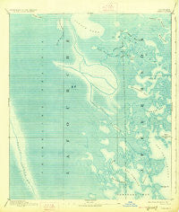
~ Creole LA topo map, 1:62500 scale, 15 X 15 Minute, Historical, 1892, updated 1927
Creole, Louisiana, USGS topographic map dated 1892.
Includes geographic coordinates (latitude and longitude). This topographic map is suitable for hiking, camping, and exploring, or framing it as a wall map.
Printed on-demand using high resolution imagery, on heavy weight and acid free paper, or alternatively on a variety of synthetic materials.
Topos available on paper, Waterproof, Poly, or Tyvek. Usually shipping rolled, unless combined with other folded maps in one order.
- Product Number: USGS-5593852
- Free digital map download (high-resolution, GeoPDF): Creole, Louisiana (file size: 9 MB)
- Map Size: please refer to the dimensions of the GeoPDF map above
- Weight (paper map): ca. 55 grams
- Map Type: POD USGS Topographic Map
- Map Series: HTMC
- Map Verison: Historical
- Cell ID: 53071
- Scan ID: 334432
- Imprint Year: 1927
- Datum: Unstated
- Map Projection: Polyconic
- Map published by United States Geological Survey
- Map Language: English
- Scanner Resolution: 600 dpi
- Map Cell Name: Creole
- Grid size: 15 X 15 Minute
- Date on map: 1892
- Map Scale: 1:62500
- Geographical region: Louisiana, United States
Neighboring Maps:
All neighboring USGS topo maps are available for sale online at a variety of scales.
Spatial coverage:
Topo map Creole, Louisiana, covers the geographical area associated the following places:
- Bayou Dosgris - Bay Dosgris - Snake Bayou - Hackberry Bay - Barataria Bay Waterway - Bayou Defond - Southwestern Louisiana Canal - North Lake - Kings Canal - Bayou Jaque - Yankee Canal - Saint Joseph Bay - Leeville Oil and Gas Field - Churn Bay - Bay Jaque - Snail Bayou - Grand Bayou - Alombro Cemetery - Mink Bayou - Bayou Cholas - Lake Pierre - West Champagne Bay - Bayou Ferblanc Oil Field - Mud Lake - Coffee Bay - Plum Point - Golden Meadow Farms - Bayou Roseau - Bay Vasier - Coffee Bayou - Bay Lizette - Creole Bay - Bayou Casse-Tete - Manila Bayou - Oaks Bay - Andre Island - Bayou Garci - Daniels Cut - Bay l'Ours - Fishermans Bay Gas Field - Raccoon Lake Gas Field - Round Lake - Plum Point Oil and Gas Field - Brusle Lake - Bay Joyeux - Kings Ridge - Bayou Andre - Bay Rambo - Lake Andre - Bay Jaque Oil Field - Hatchet Lake - Martigan Point - Raccoon Bayou - Palmetto Bayou - Live Oak Bay - East Fork Bayou L'Ours - Coffee Bay Oil Field - Caminada Bay - Old Grand Bayou - Parish Governing Authority District 9 - Snail Bayou - Lake Enfermer Oil and Gas Field - Snail Bay - Bay Desespere - Bay Diego - Lake Jesse - Fricot Bayou - Raccoon Lake - Bay De Chene Oil Field - Bayou l'Ours - John the Fool Bayou - Creole Pass - Point Des Ilettes - Bayou de Chene - Bay Tambour - Round Lake - Fishermans Bay - South Little Lake Oil and Gas Field
- Map Area ID: AREA29.529.25-90.25-90
- Northwest corner Lat/Long code: USGSNW29.5-90.25
- Northeast corner Lat/Long code: USGSNE29.5-90
- Southwest corner Lat/Long code: USGSSW29.25-90.25
- Southeast corner Lat/Long code: USGSSE29.25-90
- Northern map edge Latitude: 29.5
- Southern map edge Latitude: 29.25
- Western map edge Longitude: -90.25
- Eastern map edge Longitude: -90


