
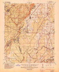
~ Collinston LA topo map, 1:62500 scale, 15 X 15 Minute, Historical, 1935, updated 1935
Collinston, Louisiana, USGS topographic map dated 1935.
Includes geographic coordinates (latitude and longitude). This topographic map is suitable for hiking, camping, and exploring, or framing it as a wall map.
Printed on-demand using high resolution imagery, on heavy weight and acid free paper, or alternatively on a variety of synthetic materials.
Topos available on paper, Waterproof, Poly, or Tyvek. Usually shipping rolled, unless combined with other folded maps in one order.
- Product Number: USGS-5593804
- Free digital map download (high-resolution, GeoPDF): Collinston, Louisiana (file size: 8 MB)
- Map Size: please refer to the dimensions of the GeoPDF map above
- Weight (paper map): ca. 55 grams
- Map Type: POD USGS Topographic Map
- Map Series: HTMC
- Map Verison: Historical
- Cell ID: 52813
- Scan ID: 334406
- Imprint Year: 1935
- Woodland Tint: Yes
- Edit Year: 1935
- Datum: NAD
- Map Projection: Polyconic
- Map published by United States Army Corps of Engineers
- Map published by United States Department of War
- Map Language: English
- Scanner Resolution: 600 dpi
- Map Cell Name: Collinston
- Grid size: 15 X 15 Minute
- Date on map: 1935
- Map Scale: 1:62500
- Geographical region: Louisiana, United States
Neighboring Maps:
All neighboring USGS topo maps are available for sale online at a variety of scales.
Spatial coverage:
Topo map Collinston, Louisiana, covers the geographical area associated the following places:
- Wham - Swartz - Love Estates - Gum Ridge - Collinston - Hancock - Hidden Oaks - Oak Ridge - Windsor - Milhaven Estates - Marcarco - Audubon Park - Eastwood Estates - Cleora (historical) - Quail Creek Estates - Bordenax - Upland - Spyker - Jonesburg - Lakewood Estates - Fleetwood Park - Town East - Puckettville - Doss (historical) - County Acres - Bardel
- Map Area ID: AREA32.7532.5-92-91.75
- Northwest corner Lat/Long code: USGSNW32.75-92
- Northeast corner Lat/Long code: USGSNE32.75-91.75
- Southwest corner Lat/Long code: USGSSW32.5-92
- Southeast corner Lat/Long code: USGSSE32.5-91.75
- Northern map edge Latitude: 32.75
- Southern map edge Latitude: 32.5
- Western map edge Longitude: -92
- Eastern map edge Longitude: -91.75


