
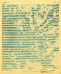
~ Bodreau LA topo map, 1:62500 scale, 15 X 15 Minute, Historical, 1895, updated 1907
Bodreau, Louisiana, USGS topographic map dated 1895.
Includes geographic coordinates (latitude and longitude). This topographic map is suitable for hiking, camping, and exploring, or framing it as a wall map.
Printed on-demand using high resolution imagery, on heavy weight and acid free paper, or alternatively on a variety of synthetic materials.
Topos available on paper, Waterproof, Poly, or Tyvek. Usually shipping rolled, unless combined with other folded maps in one order.
- Product Number: USGS-5593604
- Free digital map download (high-resolution, GeoPDF): Bodreau, Louisiana (file size: 11 MB)
- Map Size: please refer to the dimensions of the GeoPDF map above
- Weight (paper map): ca. 55 grams
- Map Type: POD USGS Topographic Map
- Map Series: HTMC
- Map Verison: Historical
- Cell ID: 51597
- Scan ID: 334287
- Imprint Year: 1907
- Datum: Unstated
- Map Projection: Unstated
- Map published by United States Geological Survey
- Map Language: English
- Scanner Resolution: 600 dpi
- Map Cell Name: Bodreau
- Grid size: 15 X 15 Minute
- Date on map: 1895
- Map Scale: 1:62500
- Geographical region: Louisiana, United States
Neighboring Maps:
All neighboring USGS topo maps are available for sale online at a variety of scales.
Spatial coverage:
Topo map Bodreau, Louisiana, covers the geographical area associated the following places:
- Morgan Harbor Pass - Isaacs Ditch - Crooked Bayou - Deep Pass - Morgan Harbor - Chicot Pass - Busters Bayou - Martinbox Bayou - Bayou Petre - Redfish Bayou - Codfish Point - Live Oak Bayou - Crooked Bayou - Bayou Ramon - Blind Pass - Eloi Bay Oil and Gas Fields - Flat Bay - Joe Shiman Pass - Lake Eloi - Treasure Island Gas Field - Bayou Muscle - Point Paulina (historical) - Parish Governing Authority District E - Bay Boudreau - Oak Mound Bayou - Twilight Harbor - Catfish Pass - Wild Goose Island - Point Cahill - Indian Mound Bay - Christmas Camp Lake - Cat Fish Point - Rawhead Island (historical) - Anderson Point - Skiff Island - Bayou Domingo - Treasure Bay - Three Bayous - Scow Pass - Long Lagoon - Conkey Cove Pass - Point Eliza - Bayou Julia - Conkey Cove - Lake of the Mound - China Pass - Hell Pass Coast - Point Lydia (historical) - Bayou la Loutre - Drum Lake - Lakes of Bayou Marron - Bayou Marron - Eloi Bay - Goose Flat - Pirate Point - Otter Bayou - Jules Cutoff - Saint Bernard Parish - Bobs Lakes - Lawson Bay - Treasure Pass - Little Mud Grass Islands - Greens Bayou - Halfmoon Lake - Mud Grass Islands - Drum Hole - Dry Bread Island - Treasure Bay Pass - Flat Bayou - Bobs Bayou - Deadmans Bayou - Chandeleur Sound Block 25 Oil Field - Bayou Tobacco - Bakers Canal - Old Harry Bayou - Bayou Pointe-en-Pointe - Southwest Pass - Lake Eugenie - Mosquito Bight - Drum Bay - Bayou Eloi - Blind Lagoon - Shell Island Lake - Kerchimbo Bay - Fishing Smack Bay - Dutchman Pass - White Log Lake - Skiff Lake - Bayou De Soto
- Map Area ID: AREA3029.75-89.5-89.25
- Northwest corner Lat/Long code: USGSNW30-89.5
- Northeast corner Lat/Long code: USGSNE30-89.25
- Southwest corner Lat/Long code: USGSSW29.75-89.5
- Southeast corner Lat/Long code: USGSSE29.75-89.25
- Northern map edge Latitude: 30
- Southern map edge Latitude: 29.75
- Western map edge Longitude: -89.5
- Eastern map edge Longitude: -89.25


