
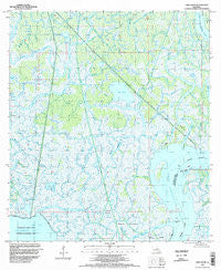
~ Lake Salve LA topo map, 1:24000 scale, 7.5 X 7.5 Minute, Historical, 1994, updated 1998
Lake Salve, Louisiana, USGS topographic map dated 1994.
Includes geographic coordinates (latitude and longitude). This topographic map is suitable for hiking, camping, and exploring, or framing it as a wall map.
Printed on-demand using high resolution imagery, on heavy weight and acid free paper, or alternatively on a variety of synthetic materials.
Topos available on paper, Waterproof, Poly, or Tyvek. Usually shipping rolled, unless combined with other folded maps in one order.
- Product Number: USGS-5590448
- Free digital map download (high-resolution, GeoPDF): Lake Salve, Louisiana (file size: 12 MB)
- Map Size: please refer to the dimensions of the GeoPDF map above
- Weight (paper map): ca. 55 grams
- Map Type: POD USGS Topographic Map
- Map Series: HTMC
- Map Verison: Historical
- Cell ID: 24638
- Scan ID: 332521
- Imprint Year: 1998
- Woodland Tint: Yes
- Aerial Photo Year: 1994
- Datum: NAD83
- Map Projection: Universal Transverse Mercator
- Map published by United States Geological Survey
- Map Language: English
- Scanner Resolution: 600 dpi
- Map Cell Name: Lake Salve
- Grid size: 7.5 X 7.5 Minute
- Date on map: 1994
- Map Scale: 1:24000
- Geographical region: Louisiana, United States
Neighboring Maps:
All neighboring USGS topo maps are available for sale online at a variety of scales.
Spatial coverage:
Topo map Lake Salve, Louisiana, covers the geographical area associated the following places:
- Sammys Bayou - Little Adams Cross Bayou - Lake Salve - Lake Pass Bayou - Little Bull Bayou - Givins Bayou - Russels Bayou - North Beach - Greens Bayou - East Bay - Lower Pass - Myrtle Bayou - Brushy Bayou - Adams Cross - Live Oak Hammock - Chicken Island Bayou - Little Cameron Bayou - Little Doctors Bayou - Outside Bayou - Myrtle Bayou - Wetfoot Hammocks - Cypress Pass - Fishtrap Bayou - Deer Island Bayou - Spanish Lake Bayou - Muddy Bayou - Mire Bayou - Big Doctors Bayou - Brushy Bayou - Willow Pass - Cross Bayou - Clarks Bayou - Shell Island Point - Big Hog Bayou - Spanish Lake - Cutoff Island - Lost Lake - Upper Pass - Little Hog Bayou - Round Bayou - Grays Bayou - Big Bull Bayou - Fourmile Bayou - Bateman Lake Gas and Oil Field - Beadles Bayou - Bayou Cameron - Bayou Haydel - Shell Island Pass
- Map Area ID: AREA29.62529.5-91.375-91.25
- Northwest corner Lat/Long code: USGSNW29.625-91.375
- Northeast corner Lat/Long code: USGSNE29.625-91.25
- Southwest corner Lat/Long code: USGSSW29.5-91.375
- Southeast corner Lat/Long code: USGSSE29.5-91.25
- Northern map edge Latitude: 29.625
- Southern map edge Latitude: 29.5
- Western map edge Longitude: -91.375
- Eastern map edge Longitude: -91.25


