
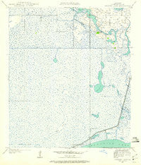
~ Browns Lake LA topo map, 1:24000 scale, 7.5 X 7.5 Minute, Historical, 1934, updated 1960
Browns Lake, Louisiana, USGS topographic map dated 1934.
Includes geographic coordinates (latitude and longitude). This topographic map is suitable for hiking, camping, and exploring, or framing it as a wall map.
Printed on-demand using high resolution imagery, on heavy weight and acid free paper, or alternatively on a variety of synthetic materials.
Topos available on paper, Waterproof, Poly, or Tyvek. Usually shipping rolled, unless combined with other folded maps in one order.
- Product Number: USGS-5588566
- Free digital map download (high-resolution, GeoPDF): Browns Lake, Louisiana (file size: 10 MB)
- Map Size: please refer to the dimensions of the GeoPDF map above
- Weight (paper map): ca. 55 grams
- Map Type: POD USGS Topographic Map
- Map Series: HTMC
- Map Verison: Historical
- Cell ID: 5729
- Scan ID: 331538
- Imprint Year: 1960
- Woodland Tint: Yes
- Survey Year: 1934
- Datum: NAD27
- Map Projection: Polyconic
- Map published by United States Geological Survey
- Map Language: English
- Scanner Resolution: 600 dpi
- Map Cell Name: Browns Lake
- Grid size: 7.5 X 7.5 Minute
- Date on map: 1934
- Map Scale: 1:24000
- Geographical region: Louisiana, United States
Neighboring Maps:
All neighboring USGS topo maps are available for sale online at a variety of scales.
Spatial coverage:
Topo map Browns Lake, Louisiana, covers the geographical area associated the following places:
- Back Ridge Canal - West Hackberry Strategic Petroleum Reserve - Browns Lake - Parish Governing Authority District 2 - Hog Island Gully - Back Ridge - Hackberry Recreation Area - Vincent Island - Hog Island - Shell Canal - Chinaberry Island - Starks North Canal - Hackberry Census Designated Place - Wild Cow Lake - Lost Ridge
- Map Area ID: AREA3029.875-93.5-93.375
- Northwest corner Lat/Long code: USGSNW30-93.5
- Northeast corner Lat/Long code: USGSNE30-93.375
- Southwest corner Lat/Long code: USGSSW29.875-93.5
- Southeast corner Lat/Long code: USGSSE29.875-93.375
- Northern map edge Latitude: 30
- Southern map edge Latitude: 29.875
- Western map edge Longitude: -93.5
- Eastern map edge Longitude: -93.375


