
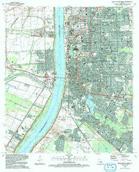
~ Baton Rouge West LA topo map, 1:24000 scale, 7.5 X 7.5 Minute, Historical, 1992, updated 1992
Baton Rouge West, Louisiana, USGS topographic map dated 1992.
Includes geographic coordinates (latitude and longitude). This topographic map is suitable for hiking, camping, and exploring, or framing it as a wall map.
Printed on-demand using high resolution imagery, on heavy weight and acid free paper, or alternatively on a variety of synthetic materials.
Topos available on paper, Waterproof, Poly, or Tyvek. Usually shipping rolled, unless combined with other folded maps in one order.
- Product Number: USGS-5588184
- Free digital map download (high-resolution, GeoPDF): Baton Rouge West, Louisiana (file size: 17 MB)
- Map Size: please refer to the dimensions of the GeoPDF map above
- Weight (paper map): ca. 55 grams
- Map Type: POD USGS Topographic Map
- Map Series: HTMC
- Map Verison: Historical
- Cell ID: 2643
- Scan ID: 331331
- Imprint Year: 1992
- Woodland Tint: Yes
- Aerial Photo Year: 1989
- Edit Year: 1992
- Field Check Year: 1991
- Datum: NAD27
- Map Projection: Lambert Conformal Conic
- Map published by United States Geological Survey
- Map Language: English
- Scanner Resolution: 600 dpi
- Map Cell Name: Baton Rouge West
- Grid size: 7.5 X 7.5 Minute
- Date on map: 1992
- Map Scale: 1:24000
- Geographical region: Louisiana, United States
Neighboring Maps:
All neighboring USGS topo maps are available for sale online at a variety of scales.
Spatial coverage:
Topo map Baton Rouge West, Louisiana, covers the geographical area associated the following places:
- Lukeville - Highland Road Estates - East Dayton - Prescott Place - Heatherstone - Midway Place - Delmont Place - Ogden Park - Port Allen Landing - Capital Heights - Walnut Hill - Highland Gardens - University Acres - Marwede - Anchorage - B and K Mobile Park - Frisco (historical) - New Dayton - Ardenwood - Westdale Terrace - Hyacinth Terrace - Collegetown - University View - Antonio - University Terrace - Dougherty Place - Concord Estates - Brusly Landing - Swart - Arlington - Floyd Place - Sharlo - Baton Rouge - Villa Ashley - Woodstone Estates - Northdale - Southdowns - Nicholson Estates - Eden Park - Magnolia Ridge - White Plains - Eastland - Port Allen - Melrose Place - Highland Hills - Court Street Estates Mobile Home Park - Howell Park Terrace - Hundred Oaks - Standard Heights - Sweetbriar - Greenville - Brookstown - Smiley Heights - McGrath Heights - College Park - West Baton Rouge - Roppolo Villa - Westdale Heights - Lynn Place - Progress - Kleinert - North Highlands - Stanford Place - Saint Gerald Park - Magnolia Heights - Moreland - Zee Zee Gardens - University Gardens - Longwood Court - South Dayton - Riverbend - Kenilworth - Sunrise - Beaulieu - Cinclare Landing (historical) - College Hills - Concord Park - Harwich - Belmont - Dent Terrace - Belfair - Meadow Lea - University Hills - Capitol View - College Drive Heights - Mirabeau Gardens - Poplar Grove Plantation - Bernard Terrace - Dayton - Pollard Estates - Plantation Mobile Home Park - Moss Side Place - Istrouma - Bogan - Magnolia Terrace - Baton Rouge Terrace - Lakecrest - Tigerland Acres - Highland Park Heights - Prescott Court
- Map Area ID: AREA30.530.375-91.25-91.125
- Northwest corner Lat/Long code: USGSNW30.5-91.25
- Northeast corner Lat/Long code: USGSNE30.5-91.125
- Southwest corner Lat/Long code: USGSSW30.375-91.25
- Southeast corner Lat/Long code: USGSSE30.375-91.125
- Northern map edge Latitude: 30.5
- Southern map edge Latitude: 30.375
- Western map edge Longitude: -91.25
- Eastern map edge Longitude: -91.125


