
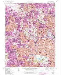
~ Clayton MO topo map, 1:24000 scale, 7.5 X 7.5 Minute, Historical, 1954, updated 1993
Clayton, Missouri, USGS topographic map dated 1954.
Includes geographic coordinates (latitude and longitude). This topographic map is suitable for hiking, camping, and exploring, or framing it as a wall map.
Printed on-demand using high resolution imagery, on heavy weight and acid free paper, or alternatively on a variety of synthetic materials.
Topos available on paper, Waterproof, Poly, or Tyvek. Usually shipping rolled, unless combined with other folded maps in one order.
- Product Number: USGS-5576940
- Free digital map download (high-resolution, GeoPDF): Clayton, Missouri (file size: 24 MB)
- Map Size: please refer to the dimensions of the GeoPDF map above
- Weight (paper map): ca. 55 grams
- Map Type: POD USGS Topographic Map
- Map Series: HTMC
- Map Verison: Historical
- Cell ID: 9014
- Scan ID: 322299
- Imprint Year: 1993
- Woodland Tint: Yes
- Photo Revision Year: 1993
- Aerial Photo Year: 1990
- Edit Year: 1993
- Field Check Year: 1954
- Survey Year: 1933
- Datum: NAD27
- Map Projection: Transverse Mercator
- Map published by United States Geological Survey
- Map Language: English
- Scanner Resolution: 600 dpi
- Map Cell Name: Clayton
- Grid size: 7.5 X 7.5 Minute
- Date on map: 1954
- Map Scale: 1:24000
- Geographical region: Missouri, United States
Neighboring Maps:
All neighboring USGS topo maps are available for sale online at a variety of scales.
Spatial coverage:
Topo map Clayton, Missouri, covers the geographical area associated the following places:
- Wells-Goodfellow - Lewis Place - Academy - Dellwood - West End - Berdell Hills - Richmond Heights - University City - Hillsdale - Cool Valley - Mary Ridge - Visitation Park - Hamilton Heights - Woodstock - Vinita Terrace - Glen Echo Park - Cabanne Place - Wydown Skinker - Schuermann Heights - Wellston - Bel-Nor - Pagedale - Saint Johns - Norwood Court - Uplands Park - Kings Oak - Clayton-Tamm - Pine Lawn - Sycamore Hills - Velda Village - Skinker-De Baliviere - Charlack - Country Club Hills - Pasadena Hills - Skinker - De Baliviere - Breckenridge Hills - Pasadena Park - Arbor Terrace - Rock Springs - Kinloch - Jennings - Woodson Terrace - Vinita Park - Fountain Park - Forest Park Southeast - Overland - Walnut Park West - Clayton - Cheltenham - Flordell Hills - Bel-Ridge - Beverly Hills - Central West End - Kingsway East - Edmundson - Ferguson - Bellerive Acres - Normandy - Kingsway West - Goodfellow Terrace - Velda Village Hills - Greendale - Hi-Pointe - Northwoods - Hanley Hills
- Map Area ID: AREA38.7538.625-90.375-90.25
- Northwest corner Lat/Long code: USGSNW38.75-90.375
- Northeast corner Lat/Long code: USGSNE38.75-90.25
- Southwest corner Lat/Long code: USGSSW38.625-90.375
- Southeast corner Lat/Long code: USGSSE38.625-90.25
- Northern map edge Latitude: 38.75
- Southern map edge Latitude: 38.625
- Western map edge Longitude: -90.375
- Eastern map edge Longitude: -90.25


