
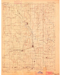
~ Mound City KS topo map, 1:125000 scale, 30 X 30 Minute, Historical, 1893, updated 1900
Mound City, Kansas, USGS topographic map dated 1893.
Includes geographic coordinates (latitude and longitude). This topographic map is suitable for hiking, camping, and exploring, or framing it as a wall map.
Printed on-demand using high resolution imagery, on heavy weight and acid free paper, or alternatively on a variety of synthetic materials.
Topos available on paper, Waterproof, Poly, or Tyvek. Usually shipping rolled, unless combined with other folded maps in one order.
- Product Number: USGS-5575734
- Free digital map download (high-resolution, GeoPDF): Mound City, Kansas (file size: 7 MB)
- Map Size: please refer to the dimensions of the GeoPDF map above
- Weight (paper map): ca. 55 grams
- Map Type: POD USGS Topographic Map
- Map Series: HTMC
- Map Verison: Historical
- Cell ID: 66100
- Scan ID: 325525
- Imprint Year: 1900
- Survey Year: 1885
- Datum: Unstated
- Map Projection: Unstated
- Map published by United States Geological Survey
- Map Language: English
- Scanner Resolution: 600 dpi
- Map Cell Name: Mound City
- Grid size: 30 X 30 Minute
- Date on map: 1893
- Map Scale: 1:125000
- Geographical region: Kansas, United States
Neighboring Maps:
All neighboring USGS topo maps are available for sale online at a variety of scales.
Spatial coverage:
Topo map Mound City, Kansas, covers the geographical area associated the following places:
- Farlinville - Worland - Mantey - La Cygne Corner - Rock - Rucker - Mulberry - Hume - Drexel Corner - Drexel - Amoret - Amos - Boicourt - Linn Valley - Prescott - Mound City - Critzer - Amsterdam - Goodrich - Jingo - South Drexel - Merwin - Cadmus - Beagle - Osawatomie - Foster - Pleasanton - New Lancaster - Fulton - La Cygne - Trading Post - Mapleton - Barnesville - Fontana - Wolfe (historical) - Dunlay - Parker
- Map Area ID: AREA38.538-95-94.5
- Northwest corner Lat/Long code: USGSNW38.5-95
- Northeast corner Lat/Long code: USGSNE38.5-94.5
- Southwest corner Lat/Long code: USGSSW38-95
- Southeast corner Lat/Long code: USGSSE38-94.5
- Northern map edge Latitude: 38.5
- Southern map edge Latitude: 38
- Western map edge Longitude: -95
- Eastern map edge Longitude: -94.5


