
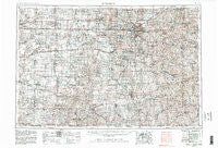
~ Lincoln NE topo map, 1:250000 scale, 1 X 2 Degree, Historical, 1955, updated 1982
Lincoln, Nebraska, USGS topographic map dated 1955.
Includes geographic coordinates (latitude and longitude). This topographic map is suitable for hiking, camping, and exploring, or framing it as a wall map.
Printed on-demand using high resolution imagery, on heavy weight and acid free paper, or alternatively on a variety of synthetic materials.
Topos available on paper, Waterproof, Poly, or Tyvek. Usually shipping rolled, unless combined with other folded maps in one order.
- Product Number: USGS-5564064
- Free digital map download (high-resolution, GeoPDF): Lincoln, Nebraska (file size: 24 MB)
- Map Size: please refer to the dimensions of the GeoPDF map above
- Weight (paper map): ca. 55 grams
- Map Type: POD USGS Topographic Map
- Map Series: HTMC
- Map Verison: Historical
- Cell ID: 68876
- Scan ID: 317927
- Imprint Year: 1982
- Woodland Tint: Yes
- Visual Version Number: 1
- Aerial Photo Year: 1978
- Edit Year: 1981
- Field Check Year: 1955
- Datum: NAD27
- Map Projection: Transverse Mercator
- Map published by United States Geological Survey
- Map published by: Military, Other
- Map Language: English
- Scanner Resolution: 600 dpi
- Map Cell Name: Lincoln
- Grid size: 1 X 2 Degree
- Date on map: 1955
- Map Scale: 1:250000
- Geographical region: Nebraska, United States
Neighboring Maps:
All neighboring USGS topo maps are available for sale online at a variety of scales.
Spatial coverage:
Topo map Lincoln, Nebraska, covers the geographical area associated the following places:
- Houston - Alexandria - Unadilla - Tangeman - Hubbell - Marian Center - Swanton - Jamaica - Pickrell - Havelock - Roca - Beaver Crossing - Syracuse - Hedrix - Nora - Raymond - Blue Springs - McCool Junction - Talmage - Badger - Waverly - Deshler - Emerald - Wilber - Milford - Townhall - Hebron - Western - Princeton - Knox - Panama - Thayer - Palmyra - Beatrice - Lewiston - Rockford - Wymore - Bethany - Gladstone - Friend - Saint Mary - Marysville (historical) - Sprague - Daykin - Bennet - Hoyle North 77 Mobile Homes - Table Rock - Steinauer - Lanham - Mission (historical) - Stoddard (historical) - Glenover - Pine Lake - Manley - Bookwalter - Staplehurst - Douglas - Pawnee City - Pleasant Hill - Barneston - Liberty - Alvo - Bixby - Eagle - Burr - Riverside Park - Mayberry - Harbour West Mobile Home Park - Cook - Burress - Countryside Estates - Walton - Shamrock Mobile Home Court - Rudy - Endicott - Holmesville - Denton - Carleton - University Place - Edgar - Diller - Milligan - Cheney - Bower (historical) - Shady Elm Mobile Home Park - Fairbury - Oak - Burchard - Bradshaw - Weeping Water - Crete - College View - Dunbar - Cortland - Hallam - Gaslight Village - Helena (historical) - Stockham - Harbine - Yankee Hill
- Map Area ID: AREA4140-98-96
- Northwest corner Lat/Long code: USGSNW41-98
- Northeast corner Lat/Long code: USGSNE41-96
- Southwest corner Lat/Long code: USGSSW40-98
- Southeast corner Lat/Long code: USGSSE40-96
- Northern map edge Latitude: 41
- Southern map edge Latitude: 40
- Western map edge Longitude: -98
- Eastern map edge Longitude: -96


