
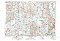
~ Fremont NE topo map, 1:250000 scale, 1 X 2 Degree, Historical, 1955, updated 1974
Fremont, Nebraska, USGS topographic map dated 1955.
Includes geographic coordinates (latitude and longitude). This topographic map is suitable for hiking, camping, and exploring, or framing it as a wall map.
Printed on-demand using high resolution imagery, on heavy weight and acid free paper, or alternatively on a variety of synthetic materials.
Topos available on paper, Waterproof, Poly, or Tyvek. Usually shipping rolled, unless combined with other folded maps in one order.
- Product Number: USGS-5564046
- Free digital map download (high-resolution, GeoPDF): Fremont, Nebraska (file size: 23 MB)
- Map Size: please refer to the dimensions of the GeoPDF map above
- Weight (paper map): ca. 55 grams
- Map Type: POD USGS Topographic Map
- Map Series: HTMC
- Map Verison: Historical
- Cell ID: 68791
- Scan ID: 317918
- Imprint Year: 1974
- Woodland Tint: Yes
- Visual Version Number: 1
- Aerial Photo Year: 1971
- Edit Year: 1971
- Field Check Year: 1955
- Datum: Unstated
- Map Projection: Transverse Mercator
- Map published by United States Geological Survey
- Map Language: English
- Scanner Resolution: 600 dpi
- Map Cell Name: Fremont
- Grid size: 1 X 2 Degree
- Date on map: 1955
- Map Scale: 1:250000
- Geographical region: Nebraska, United States
Neighboring Maps:
All neighboring USGS topo maps are available for sale online at a variety of scales.
Spatial coverage:
Topo map Fremont, Nebraska, covers the geographical area associated the following places:
- Snyder - Creston - Tekamah - Mead - Westlake Mobile Home Park - Kennard - Abel - Loma - Country Estates Mobile Home Park - Cornlea - Malmo - Carriage House Estates - Valley - Leigh - Brainard - College View Park - Oconee - Arizona - Madison - Green Meadows - Arborville - Ralston - Lane - Fremont - Colon - Newman Grove - Bertha - Park Meadow Estates Mobile Home Community - Millard Mobile Home Park - Emerick - Herman - Crowell - Little Sioux - Saint Charles - River Sioux - Hi Land Mobile Home Park - Touhy - Fullerton - C and K Mobile Home Park - Heber - Plattford (historical) - Richfield - Saint Bernard - Overland - Garrison - Linoma Beach - Big Sandy Lake - Monterey - Caradon Mobile Home Park - Dwight - West Point - Humphrey - Mercer - Hooper - Fontanelle - Stromsburg - Millard - Lake Platte View - Agnew - Stanton - South Broad Trailer Court - Winslow - Uehling - Woodcliff - Millerton - North Bend - Heun - Elk City - Genoa - Swedehome - Valparaiso - Iron Horse - Lindsay - Ithaca - Closter - Admah (historical) - Bennington - Edholm - Bee - Silver Creek - Springfield - Genes Trailer Court - Cullom - Gresham - Vorhees - Monroe - Tarnov - Omaha Regency - Merchiston - Krakow - Surprise - Beemer - Osceola - Argo (historical) - Ames - Lyons - Debolt - Portal - Bruno - Boys Town
- Map Area ID: AREA4241-98-96
- Northwest corner Lat/Long code: USGSNW42-98
- Northeast corner Lat/Long code: USGSNE42-96
- Southwest corner Lat/Long code: USGSSW41-98
- Southeast corner Lat/Long code: USGSSE41-96
- Northern map edge Latitude: 42
- Southern map edge Latitude: 41
- Western map edge Longitude: -98
- Eastern map edge Longitude: -96


