
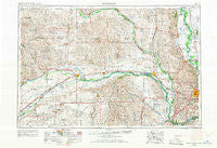
~ Fremont NE topo map, 1:250000 scale, 1 X 2 Degree, Historical, 1955, updated 1966
Fremont, Nebraska, USGS topographic map dated 1955.
Includes geographic coordinates (latitude and longitude). This topographic map is suitable for hiking, camping, and exploring, or framing it as a wall map.
Printed on-demand using high resolution imagery, on heavy weight and acid free paper, or alternatively on a variety of synthetic materials.
Topos available on paper, Waterproof, Poly, or Tyvek. Usually shipping rolled, unless combined with other folded maps in one order.
- Product Number: USGS-5564042
- Free digital map download (high-resolution, GeoPDF): Fremont, Nebraska (file size: 21 MB)
- Map Size: please refer to the dimensions of the GeoPDF map above
- Weight (paper map): ca. 55 grams
- Map Type: POD USGS Topographic Map
- Map Series: HTMC
- Map Verison: Historical
- Cell ID: 68791
- Scan ID: 317916
- Imprint Year: 1966
- Woodland Tint: Yes
- Aerial Photo Year: 1953
- Edit Year: 1966
- Field Check Year: 1955
- Datum: Unstated
- Map Projection: Transverse Mercator
- Map published by United States Geological Survey
- Map published by United States Army Corps of Engineers
- Map published by United States Army
- Map Language: English
- Scanner Resolution: 600 dpi
- Map Cell Name: Fremont
- Grid size: 1 X 2 Degree
- Date on map: 1955
- Map Scale: 1:250000
- Geographical region: Nebraska, United States
Neighboring Maps:
All neighboring USGS topo maps are available for sale online at a variety of scales.
Spatial coverage:
Topo map Fremont, Nebraska, covers the geographical area associated the following places:
- King Lake - Clarks - Ceresco - Monterey - De Soto - Coniglias Mobile Home Park - South Broad Trailer Court - Millerton - Linoma Beach - Cullom - Platte Center - Stanton - Kennard - Ulysses - Ashland - Peaceful Valley Mobile Homes - Snyder - Washington - Arlington - College View Park - Fairview (historical) - Regency II Mobile Home Park - Battle Creek - Oconee - Richland - Country Estates Mobile Home Park - Malmo - Fairview (historical) - West Point - Dodge - Aloys - Boone - Octavia - Gardiner - Wann - Bee - Bertha - Vorhees - C and K Mobile Home Park - Aksarben Mobile Home Park - Venice - Argo (historical) - Agnew - Cedar Creek - Bismarck - Howells - Genes Trailer Court - Park Meadow Estates Mobile Home Community - Wahoo - Tarnov - Scribner - Richfield - Mead - Edholm - Ithaca - Durant - Enola - Swedeburg - Rosenburg - Briggs - Abel - Abie - Merchiston - Millard - Beacon View - Rogers - Blair - Iron Horse - Bellwood - Closter - Riverside - Overland - Green Acres Mobile Home Community - Leigh - Cedar Bluffs - Wagners Lake - Leshara - Monroe - Touhy - Fort Calhoun - Omaha Regency - Duncan - Chalco - Lyons - Olean - Hordville - Carriage House Estates - Kalamazoo - Debolt - Lake Platte View - Wisner - Fontanelle - Springfield - Surprise - Skyline - Ralston - Garrison - Madison - Bennington - Nickerson
- Map Area ID: AREA4241-98-96
- Northwest corner Lat/Long code: USGSNW42-98
- Northeast corner Lat/Long code: USGSNE42-96
- Southwest corner Lat/Long code: USGSSW41-98
- Southeast corner Lat/Long code: USGSSE41-96
- Northern map edge Latitude: 42
- Southern map edge Latitude: 41
- Western map edge Longitude: -98
- Eastern map edge Longitude: -96


