
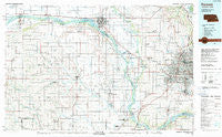
~ Fremont NE topo map, 1:100000 scale, 30 X 60 Minute, Historical, 1982, updated 1982
Fremont, Nebraska, USGS topographic map dated 1982.
Includes geographic coordinates (latitude and longitude). This topographic map is suitable for hiking, camping, and exploring, or framing it as a wall map.
Printed on-demand using high resolution imagery, on heavy weight and acid free paper, or alternatively on a variety of synthetic materials.
Topos available on paper, Waterproof, Poly, or Tyvek. Usually shipping rolled, unless combined with other folded maps in one order.
- Product Number: USGS-5563686
- Free digital map download (high-resolution, GeoPDF): Fremont, Nebraska (file size: 25 MB)
- Map Size: please refer to the dimensions of the GeoPDF map above
- Weight (paper map): ca. 55 grams
- Map Type: POD USGS Topographic Map
- Map Series: HTMC
- Map Verison: Historical
- Cell ID: 67551
- Scan ID: 317727
- Imprint Year: 1982
- Woodland Tint: Yes
- Aerial Photo Year: 1978
- Edit Year: 1982
- Datum: NAD27
- Map Projection: Universal Transverse Mercator
- Map published by United States Geological Survey
- Map Language: English
- Scanner Resolution: 600 dpi
- Map Cell Name: Fremont
- Grid size: 30 X 60 Minute
- Date on map: 1982
- Map Scale: 1:100000
- Geographical region: Nebraska, United States
Neighboring Maps:
All neighboring USGS topo maps are available for sale online at a variety of scales.
Spatial coverage:
Topo map Fremont, Nebraska, covers the geographical area associated the following places:
- Fort Calhoun - Nimburg - Lane - Fairview (historical) - Arlington - Papillion - Rogers - Linwood - Gretna - Valparaiso - Ralston - Riverside - Touhy - Colon - Aksarben Mobile Home Park - Chalco - Linoma Beach - Kennard - Melia - Ceresco - North Bend - De Soto - Regency II Mobile Home Park - Beacon View - Ames - Ashland - Maplewood Estates - Rescue (historical) - Cedar Bluffs - Mead - Fremont - Richfield - Skyline - Weston - South Bend - Venice - Yutan - Abie - Hi Land Mobile Home Park - Paradise Estates - Washington - Big Sandy Lake - Irvington - Woodcliff - Abel - Rellers Park - Inglewood - Bennington - Memphis - Iron Horse - Elkhorn - Millard - Westlake Mobile Home Park - Wahoo - Leshara - Green Meadows - Cedar Creek - Briggs - Mercer - Bruno - Springfield - Prague - Agnew - Valley - Meadow - La Vista - Ithaca - Debolt - Swedeburg - Waterloo - C and K Mobile Home Park - Park Meadow Estates Mobile Home Community - Millard Mobile Home Park - Plattford (historical) - Caradon Mobile Home Park - Loma - Omaha Regency - Coniglias Mobile Home Park - Wann - Boys Town - Peaceful Valley Mobile Homes - King Lake - Midway Trailer Court - South Broad Trailer Court - Lake Platte View - Portal - Morse Bluff - Elk City - Malmo - Cullom
- Map Area ID: AREA41.541-97-96
- Northwest corner Lat/Long code: USGSNW41.5-97
- Northeast corner Lat/Long code: USGSNE41.5-96
- Southwest corner Lat/Long code: USGSSW41-97
- Southeast corner Lat/Long code: USGSSE41-96
- Northern map edge Latitude: 41.5
- Southern map edge Latitude: 41
- Western map edge Longitude: -97
- Eastern map edge Longitude: -96


