
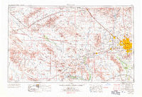
~ Phoenix AZ topo map, 1:250000 scale, 1 X 2 Degree, Historical, 1969, updated 1971
Phoenix, Arizona, USGS topographic map dated 1969.
Includes geographic coordinates (latitude and longitude). This topographic map is suitable for hiking, camping, and exploring, or framing it as a wall map.
Printed on-demand using high resolution imagery, on heavy weight and acid free paper, or alternatively on a variety of synthetic materials.
Topos available on paper, Waterproof, Poly, or Tyvek. Usually shipping rolled, unless combined with other folded maps in one order.
- Product Number: USGS-5549616
- Free digital map download (high-resolution, GeoPDF): Phoenix, Arizona (file size: 17 MB)
- Map Size: please refer to the dimensions of the GeoPDF map above
- Weight (paper map): ca. 55 grams
- Map Type: POD USGS Topographic Map
- Map Series: HTMC
- Map Verison: Historical
- Cell ID: 74961
- Scan ID: 315569
- Imprint Year: 1971
- Woodland Tint: Yes
- Aerial Photo Year: 1953
- Edit Year: 1970
- Field Check Year: 1954
- Datum: Unstated
- Map Projection: Transverse Mercator
- Map published by United States Geological Survey
- Map published by United States Army Corps of Engineers
- Map published by United States Army
- Map Language: English
- Scanner Resolution: 600 dpi
- Map Cell Name: Phoenix
- Grid size: 1 X 2 Degree
- Date on map: 1969
- Map Scale: 1:250000
- Geographical region: Arizona, United States
Neighboring Maps:
All neighboring USGS topo maps are available for sale online at a variety of scales.
Spatial coverage:
Topo map Phoenix, Arizona, covers the geographical area associated the following places:
- Cactus - Wonder Rift - Gila Crossing - Cartwright - Bethany Grand Mobile Home Park - Cotton Center - Bonaventure Mobile Home Community - Stony Mountain Villas - Vicksburg - Braemar VII - Lazy D Trailer Ranch - Thunderbird Valley Number Two - Grover Terrace Mobile Home Park - Estate Monterra - Lake Biltmore Estates - Byrds Mobile Park - Aristocrat Trailer Park (historical) - Deer Creek - Adobe - Western Acres Mobile Home Park - Eighteen Bells Mobile Home Park - Cashion - Big Reef Mill - Holiday Spa Mobile Home Park - Three Fountains Mobile Home Park - Co-op Village - Sheffield Place - Royal Glen Mobile Home Park - Rancho Mobile Estates - Santa Cruz - Steeplechase - Village Park - Glendale West Mobile Home Park - Allenville - Roles Inn of America - Trailer Corral - Conger - Glendale - Lazy T Mobile Home Park - Woodridge VI - Peoria Polynesian Village Mobile Home Park - Wabash Trailer Court - Claremont Place - Estrella Valley Mobile Home Park - Wranglers Roost - Greentrails - Palo Verde Mobile Home and Recreational Vehicle Park - Chaparral - Stagecoach Trailer Park - Desert Estates Mobile Home Park - Dysart (historical) - Shadow Canyon - Peoria Estates - Valencia - Trail Inn Lodge - Country Club Trailer Grove - Webb - Glendale Cascade Mobile Home Park - Peoria Palms Mobile Home Park - Montezuma - Longhorn Ranch II - Fennemore - Paradise Valley Mobile Home Park - Vistancia - Colony Biltmore IV - Centennial - Lone Butte Ranch - Turf Trailer Lodge - Sunray Manor - Fairwood VIII - WillowBrook II - Central Park Village - Paradise Shadows Mobile Home Park - Matthie - Centura West - Casa del Sol Resorts Number One - Glen Canyon Trailer Park - Covered Wagon Mobile Home Park - Montara - Squaw Peak Terrace - Dixie - Palm Shadows Mobile Home Park - San Miguel - Bronze Boot - Windmill - Country West Mobile Home Park - Shadow Hills Mobile Home Park - Ambrosia Mill - Anthem - Maricopa Village - La Montana del Sur - Tonopah - Sunset North - Mountain View Trailer Court - Waddell - Out West Trailer Park - Suncrest Villas East - Palm Drive Trailer Ranch - McDowell Trailer Village - The Citadel
- Map Area ID: AREA3433-114-112
- Northwest corner Lat/Long code: USGSNW34-114
- Northeast corner Lat/Long code: USGSNE34-112
- Southwest corner Lat/Long code: USGSSW33-114
- Southeast corner Lat/Long code: USGSSE33-112
- Northern map edge Latitude: 34
- Southern map edge Latitude: 33
- Western map edge Longitude: -114
- Eastern map edge Longitude: -112


