
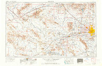
~ Phoenix AZ topo map, 1:250000 scale, 1 X 2 Degree, Historical, 1954, updated 1964
Phoenix, Arizona, USGS topographic map dated 1954.
Includes geographic coordinates (latitude and longitude). This topographic map is suitable for hiking, camping, and exploring, or framing it as a wall map.
Printed on-demand using high resolution imagery, on heavy weight and acid free paper, or alternatively on a variety of synthetic materials.
Topos available on paper, Waterproof, Poly, or Tyvek. Usually shipping rolled, unless combined with other folded maps in one order.
- Product Number: USGS-5549610
- Free digital map download (high-resolution, GeoPDF): Phoenix, Arizona (file size: 17 MB)
- Map Size: please refer to the dimensions of the GeoPDF map above
- Weight (paper map): ca. 55 grams
- Map Type: POD USGS Topographic Map
- Map Series: HTMC
- Map Verison: Historical
- Cell ID: 74961
- Scan ID: 315566
- Imprint Year: 1964
- Edit Year: 1964
- Field Check Year: 1954
- Datum: Unstated
- Map Projection: Transverse Mercator
- Map published by United States Army Corps of Engineers
- Map published by United States Army
- Map Language: English
- Scanner Resolution: 600 dpi
- Map Cell Name: Phoenix
- Grid size: 1 X 2 Degree
- Date on map: 1954
- Map Scale: 1:250000
- Geographical region: Arizona, United States
Neighboring Maps:
All neighboring USGS topo maps are available for sale online at a variety of scales.
Spatial coverage:
Topo map Phoenix, Arizona, covers the geographical area associated the following places:
- Engesser Junction - S C Townhouse Mobile Home Estates - Rollin W Mobile Home Ranch - Liberty - Gila Crossing - Saint Johns Mission - Pepper Ridge - McMicken - Braemar VII - Trailer Corral - Paradise Valley Mobile Home Park - Utting - Glendale - Maricopa Village - Heaton - Chaparral - Arlington - Autumn Ridge - Agua Fria - Turtle Creek - Wigwam Villa Mobile Home Park - Desert Valley Estates - Sheffield Place - Matthie - Westcliff Park - Plaza Trailer Inn - Country Villa Mobile Home Park - Village on the Lakes - Wabash Trailer Court - Parkview North - Paradise Grove Family Park - Thunderbird Valley Number Two - Cheyenne Village - Bell Casas Mobile Home Estates - Shadow Mountain - Marco Polo Mobile Home Park - Big Reef Mill - San Miguel - Chris-Town Travel Trailer and Mobile Home Park - Estrella Camp - Vicksburg - New Home Mobile Park - Cottonwood Ranch - Santa Cruz - Val Vista Trailer Park - Trail Inn Lodge - Love - Goodyear - Palo Verde - Amberwood North - Parque Vista Estates - Suncrest Mobile Home Park I - Camel - Cotton Center - Aztec Mobile Home Park - Liberty Mobile Home Park - Bel-Aire Trailer Park - Liberty Village - Vicksburg Junction - Rancho Mobile Estates - La Montana del Sur - Brandywine - Peoria - Paradise Valley Oasis - Sahara Mobile Home Park - Suncrest Villas East - Maryvale Terrace - Tolleson - La Fontana Heights - Out West Trailer Park - Quail Lane - Mountain View Meadows - La Terraza - Boulder Ridge Mobile Home Park - Paradise Shadows Mobile Home Park - Citrus Grove Trailer Park - Rose Lane Trailer Park - Wintersburg - Grover Terrace Mobile Home Park - Wonder Rift - Oregon Trail Mobile Home Park - Purple Sage Mobile Home Park - Central Mobile Home Park - Moon Valley Mobile Home Estates - Blue Sky Mobile Estates - Paradise City - Centennial - Wayne - Gillespie - WillowBrook II - Sun Valley Trailer Park - Gladden - Casa Rosa - Palms Trailer Park - Villa Novena - Young America West - Hoka Tiki Mobile Village - Blue Palm Mobile Home Park - Phoenix West Mobile Home Park - J and M Trailer Park
- Map Area ID: AREA3433-114-112
- Northwest corner Lat/Long code: USGSNW34-114
- Northeast corner Lat/Long code: USGSNE34-112
- Southwest corner Lat/Long code: USGSSW33-114
- Southeast corner Lat/Long code: USGSSE33-112
- Northern map edge Latitude: 34
- Southern map edge Latitude: 33
- Western map edge Longitude: -114
- Eastern map edge Longitude: -112


