
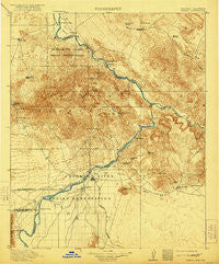
~ Parker AZ topo map, 1:125000 scale, 30 X 30 Minute, Historical, 1911, updated 1921
Parker, Arizona, USGS topographic map dated 1911.
Includes geographic coordinates (latitude and longitude). This topographic map is suitable for hiking, camping, and exploring, or framing it as a wall map.
Printed on-demand using high resolution imagery, on heavy weight and acid free paper, or alternatively on a variety of synthetic materials.
Topos available on paper, Waterproof, Poly, or Tyvek. Usually shipping rolled, unless combined with other folded maps in one order.
- Product Number: USGS-5549410
- Free digital map download (high-resolution, GeoPDF): Parker, Arizona (file size: 9 MB)
- Map Size: please refer to the dimensions of the GeoPDF map above
- Weight (paper map): ca. 55 grams
- Map Type: POD USGS Topographic Map
- Map Series: HTMC
- Map Verison: Historical
- Cell ID: 66285
- Scan ID: 315388
- Imprint Year: 1921
- Survey Year: 1909
- Datum: Unstated
- Map Projection: Unstated
- Map published by United States Geological Survey
- Map Language: English
- Scanner Resolution: 600 dpi
- Map Cell Name: Parker
- Grid size: 30 X 30 Minute
- Date on map: 1911
- Map Scale: 1:125000
- Geographical region: Arizona, United States
Neighboring Maps:
All neighboring USGS topo maps are available for sale online at a variety of scales.
Spatial coverage:
Topo map Parker, Arizona, covers the geographical area associated the following places:
- Lakeview Mobile Home Park - Bransons Mobile Home Park - Big River - Bluewater - Lake Havasu City - Bluewater - Earp - Parker - Parker Strip - Larneds Landing - Calzona - Cienega Springs - Havasu Palms - Parker Trailer Park - Lazy D Mobile Home Park - Parker Dam - Cross Roads - Black Meadow Landing - Havasu Lake - Tin Shack (historical)
- Map Area ID: AREA34.534-114.5-114
- Northwest corner Lat/Long code: USGSNW34.5-114.5
- Northeast corner Lat/Long code: USGSNE34.5-114
- Southwest corner Lat/Long code: USGSSW34-114.5
- Southeast corner Lat/Long code: USGSSE34-114
- Northern map edge Latitude: 34.5
- Southern map edge Latitude: 34
- Western map edge Longitude: -114.5
- Eastern map edge Longitude: -114


