
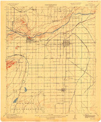
~ Mesa AZ topo map, 1:62500 scale, 15 X 15 Minute, Historical, 1915
Mesa, Arizona, USGS topographic map dated 1915.
Includes geographic coordinates (latitude and longitude). This topographic map is suitable for hiking, camping, and exploring, or framing it as a wall map.
Printed on-demand using high resolution imagery, on heavy weight and acid free paper, or alternatively on a variety of synthetic materials.
Topos available on paper, Waterproof, Poly, or Tyvek. Usually shipping rolled, unless combined with other folded maps in one order.
- Product Number: USGS-5548278
- Free digital map download (high-resolution, GeoPDF): Mesa, Arizona (file size: 5 MB)
- Map Size: please refer to the dimensions of the GeoPDF map above
- Weight (paper map): ca. 55 grams
- Map Type: POD USGS Topographic Map
- Map Series: HTMC
- Map Verison: Historical
- Cell ID: 57554
- Scan ID: 703561
- Survey Year: 1913
- Datum: Unstated
- Map Projection: Unstated
- Map published by United States Geological Survey
- Map Language: English
- Scanner Resolution: 508 dpi
- Map Cell Name: Mesa
- Grid size: 15 X 15 Minute
- Date on map: 1915
- Map Scale: 1:62500
- Geographical region: Arizona, United States
Neighboring Maps:
All neighboring USGS topo maps are available for sale online at a variety of scales.
Spatial coverage:
Topo map Mesa, Arizona, covers the geographical area associated the following places:
- Sunrise Vista Mobile Home Park - Sundial Mobile Park - Seyenne Vista Mobile Home Park - Suntrails - Breckenridge Manor - Lazona Trailer Court - Lariat Tra-Tel Trailer Court - Wheel Inn Ranch Mobile Home Park - Valley Mobile Homes Estate - M and M Mobile Village - La Casita Mobile Park - Wintercone Park - Green Acres Trailer Court - Citrus Grove Trailer Court - Orangetree - Brentwood Mobile Manor - MonDak Mobile Home Park - Roadrunner Lake Resort Mobile Home Park - Garden Spot Mobile Home Park - Evergreen Villa Mobile Home Park - Fuller Ranch - Tempe Royal Palms - Peterson (historical) - Summerplace Green - Dobson Shores - Mesa Grande Trailer Ranch - Wagon Wheel Mobile Ranch - Estates La Colina - Imperial Mobile Home Park - Contempo Tempe - Holiday Village Mobile Home Park - Alma Gardens - Burgundy Hill - Peterson - Green Tree Mobile Home Park - Sunview - Apache West Mobile Village - Desert Villas - Amberwood - Montecito Mobile Home Estates - Sunridge IV - Chandler - Big Pine Mobile Home Park - Glenview Estates - Beverly Trailer Park - Tempe Junction - Rancho de Chandler - Mountain View Mobile Home Park - Rancho Tempe Family and Adult Mobile Home Park - Silvergate II - Pozo - Renaissance - Raintree - Woodland Heights - Nortons Corner - Trail Riders Holiday Park - Alma Meadows Mobile Home Park - Venture Out Recreational Vehicle Resort - Prado del Sol - Guadalupe - The Trails III - Hacienda Solano Resort Mobile Home Park - Helena - Kay-Bee Mobile Villa - Tempe Cascade - Marlborough Park - Bonds Trailer Park - Stonegate Crossing - Mission Valley - Admiral Trailer Park - San Carlos - The West Winds Trailer Court - Mesa - Parkside - Corona Village - Dusk File - Tempe - Sunshine Valley Mobile Home Park - Brentwood West - Tempe Cascade Mobile Home Estates - Shady Ranch Trailer Lodge - Kon Tiki Mobile Home Park - Canyon Run - Sonora Town - The Landings - Cypress Estates - Casa Linda - Quail Place - Brentwood West Mobile Home Park - Mesa Village Mobile Home Park - Crestview - Tremaine - Hacienda Solano Park - West Chandler - Woodridge Lakes - Heatherbrook - McQueen - Horseshoe Mobile Home Park - Castillo Nuevo Mobile Home Park - Los Tesoros
- Map Area ID: AREA33.533.25-112-111.75
- Northwest corner Lat/Long code: USGSNW33.5-112
- Northeast corner Lat/Long code: USGSNE33.5-111.75
- Southwest corner Lat/Long code: USGSSW33.25-112
- Southeast corner Lat/Long code: USGSSE33.25-111.75
- Northern map edge Latitude: 33.5
- Southern map edge Latitude: 33.25
- Western map edge Longitude: -112
- Eastern map edge Longitude: -111.75


