
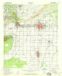
~ Mesa AZ topo map, 1:62500 scale, 15 X 15 Minute, Historical, 1952, updated 1960
Mesa, Arizona, USGS topographic map dated 1952.
Includes geographic coordinates (latitude and longitude). This topographic map is suitable for hiking, camping, and exploring, or framing it as a wall map.
Printed on-demand using high resolution imagery, on heavy weight and acid free paper, or alternatively on a variety of synthetic materials.
Topos available on paper, Waterproof, Poly, or Tyvek. Usually shipping rolled, unless combined with other folded maps in one order.
- Product Number: USGS-5548274
- Free digital map download (high-resolution, GeoPDF): Mesa, Arizona (file size: 7 MB)
- Map Size: please refer to the dimensions of the GeoPDF map above
- Weight (paper map): ca. 55 grams
- Map Type: POD USGS Topographic Map
- Map Series: HTMC
- Map Verison: Historical
- Cell ID: 57554
- Scan ID: 314797
- Imprint Year: 1960
- Woodland Tint: Yes
- Aerial Photo Year: 1951
- Datum: NAD27
- Map Projection: Polyconic
- Map published by United States Geological Survey
- Map published by United States Army Corps of Engineers
- Map published by United States Army
- Map Language: English
- Scanner Resolution: 600 dpi
- Map Cell Name: Mesa
- Grid size: 15 X 15 Minute
- Date on map: 1952
- Map Scale: 1:62500
- Geographical region: Arizona, United States
Neighboring Maps:
All neighboring USGS topo maps are available for sale online at a variety of scales.
Spatial coverage:
Topo map Mesa, Arizona, covers the geographical area associated the following places:
- The Trails III - Peterson (historical) - Wagon Wheel Mobile Ranch - Casa Linda - Mesa Gardens Mobile Home Park - Brentwood West - Normal Junction - Cibola Mobile Home Park - Sonora Town - Ahwatukee - Camelot Luxury Homes - Alta Mira - Country Cousins Mobile Mecca - Sun Tech - Palo Verde Mobile Manor - Suncrest Villas Chandler - Wishing Well Trailer Park - Dobson Shores - Brentwood Mobile Manor - Contempo Tempe Mobile Home Park - Breckenridge Manor - Mesa Village Mobile Home Park - Silvergate II - Shadow Mountain Village - Roadrunner Lake Resort Mobile Home Park - Kingsgate - Los Tesoros - Renaissance - Big Palm Trailer Park - Green Acres Trailer Court - El Mirage Mobile Home Park - Village of Gila Springs - El Dorado Mobile Home Resort - Homestead - Holiday Village Mobile Home Park - Woodside - Hacienda Solano Resort Mobile Home Park - Lazona Trailer Court - Womack East - Cedar Ridge - Silvergate Trails - Suncrest Villas Mesa - Mesa Grande Trailer Ranch - Alma Meadows Mobile Home Park - Summer Place Trails - A and F Trailer Court - Quail Place - Reynolds Trailer Court - West Chandler - Salt River - Scottsdale Trailer Corral - Gilbert - Parkview Mesa - Venture Out Recreational Vehicle Resort - Prado del Sol - Raintree - Greenhaven Mobile Park - San Tan Mobile Village - Rancho Rio Vista Mobile Home Park - Estates La Colina - Legante Paseo - Paradise View Mobile Home Park - Wheel Inn Ranch - Kon Tiki Mobile Home Park - Valley Mobile Homes Estate - Alma Gardens - Marlborough Mesa - Tovrea - Horseshoe Mobile Home Park - Evergreen Villa Mobile Home Park - Shadow Mountain Village Scottsdale - Corona Village - Minnesota Court - Hawaiian Village Mobile Home Park - Golden West Estates - Esplanada - Mesa Travelodge Mobile Home Park - Continental Tempe - Admiral Trailer Park - Woodcreek - Chaparral Mobile Village - Woodridge Lakes - Tempe Cascade Mobile Home Estates - Holiday Village Mobile Home Park - The Pointe at South Mountain - Orangetree - Tempe - Warner Park - Parkside - The Home Place - Wintercone Park - Rancho de Arboleda - Summerplace Green - The Lakes - Rancho Tempe Family and Adult Mobile Home Park - Hightown - Glenview Estates - La Casita Mobile Park - Central Ridge - Redwood Gardens Mobile Home Park
- Map Area ID: AREA33.533.25-112-111.75
- Northwest corner Lat/Long code: USGSNW33.5-112
- Northeast corner Lat/Long code: USGSNE33.5-111.75
- Southwest corner Lat/Long code: USGSSW33.25-112
- Southeast corner Lat/Long code: USGSSE33.25-111.75
- Northern map edge Latitude: 33.5
- Southern map edge Latitude: 33.25
- Western map edge Longitude: -112
- Eastern map edge Longitude: -111.75


