
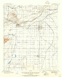
~ Mesa AZ topo map, 1:62500 scale, 15 X 15 Minute, Historical, 1913, updated 1955
Mesa, Arizona, USGS topographic map dated 1913.
Includes geographic coordinates (latitude and longitude). This topographic map is suitable for hiking, camping, and exploring, or framing it as a wall map.
Printed on-demand using high resolution imagery, on heavy weight and acid free paper, or alternatively on a variety of synthetic materials.
Topos available on paper, Waterproof, Poly, or Tyvek. Usually shipping rolled, unless combined with other folded maps in one order.
- Product Number: USGS-5548272
- Free digital map download (high-resolution, GeoPDF): Mesa, Arizona (file size: 5 MB)
- Map Size: please refer to the dimensions of the GeoPDF map above
- Weight (paper map): ca. 55 grams
- Map Type: POD USGS Topographic Map
- Map Series: HTMC
- Map Verison: Historical
- Cell ID: 57554
- Scan ID: 314796
- Imprint Year: 1955
- Survey Year: 1913
- Datum: NAD27
- Map Projection: Polyconic
- Map published by United States Geological Survey
- Map Language: English
- Scanner Resolution: 600 dpi
- Map Cell Name: Mesa
- Grid size: 15 X 15 Minute
- Date on map: 1913
- Map Scale: 1:62500
- Geographical region: Arizona, United States
Neighboring Maps:
All neighboring USGS topo maps are available for sale online at a variety of scales.
Spatial coverage:
Topo map Mesa, Arizona, covers the geographical area associated the following places:
- San Carlos - Casas del Campo Mobile Home Park - Rancho Tempe Family and Adult Mobile Home Park - The Landings - Hawaiian Village Mobile Home Park - West Chandler - Mission Valley - Riviera Mobile Home Park - Desert Villas - Suncrest Villas Mesa - Rancho de Arboleda - Bonds Trailer Park - Lehi - Palo Verde Mobile Manor - Kingsgate - Suntree - Elmwood Trailer Park - Alma Meadows Mobile Home Park - Heatherbrook - Renaissance - Citrus Grove Trailer Court - Tempe Cascade - Valley Mobile Homes Estate - Chandler - Corona Village - Brentwood West - Wintercone Park - Stonegate Crossing - Mesa Grande Trailer Ranch - Coronado Mobile Home Park - Prado del Sol - Glenview Estates - Raintree - Palm Gardens Mobile Home Manor - West Mesa Trailer Court - Cambridge Heights - Continental Tempe - Kyrene - Garden Spot Mobile Home Park - Quail Place - Wheel Inn Ranch Mobile Home Park - Dobson Ranch - Meadowvale - Falfa - Shadow Mountain Village Scottsdale - Mesa Travelodge Mobile Home Park - Gilbert - Parkview Mesa - Tempe Royal Palms - El Mirage - Sagewood - Woodland Heights - Southern Palms Trailer Park - Hyde Park Lodge - Alma Gardens - Pozo - Colonial Coronita - The Home Place - Greenhaven Mobile Park - Woodridge Lakes - Golden West Estates - Homestead - San Tan Mobile Village - Silvergate Trails - Woodglen - Shadow Mountain Village - Keats Crossing - Paradise Palms Trailer Resorts - Raintree Luxury Homes - Pony Acres Mobile Home Park - Sunridge IV - Pepperwood - Mesa Village Mobile Home Park - Karmella Mobile Home Park - Mesa Gardens Mobile Home Park - McQueen - Burgundy Hill - Desert Sage Mobile Manor - Rancho de Chandler - Amberwood II - Hacienda Solano Resort Mobile Home Park - Starlite Trailer Park - Cibola Mobile Home Park - Ambassador Downs Mobile Home Park - El Dorado Mobile Home Resort - Parkview Village Mobile Home and Recreational Vehicle Park - Roadrunner Lake Resort Mobile Home Park - Crestview - Normal Junction - Country Club Village Mobile Home Park - Ahwatukee - Sunshine Valley Mobile Home Park - Cypress Estates - Big Palm Trailer Park - Marlborough Mesa - Imperial Mobile Home Park - Los Maderas - Eastway Mobile Home Park - Wagon Wheel Mobile Ranch - Tovrea
- Map Area ID: AREA33.533.25-112-111.75
- Northwest corner Lat/Long code: USGSNW33.5-112
- Northeast corner Lat/Long code: USGSNE33.5-111.75
- Southwest corner Lat/Long code: USGSSW33.25-112
- Southeast corner Lat/Long code: USGSSE33.25-111.75
- Northern map edge Latitude: 33.5
- Southern map edge Latitude: 33.25
- Western map edge Longitude: -112
- Eastern map edge Longitude: -111.75


