
~ Livingston Hills AZ topo map, 1:62500 scale, 15 X 15 Minute, Historical, 1962, updated 1984
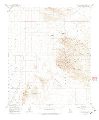
Livingston Hills, Arizona, USGS topographic map dated 1962.
Includes geographic coordinates (latitude and longitude). This topographic map is suitable for hiking, camping, and exploring, or framing it as a wall map.
Printed on-demand using high resolution imagery, on heavy weight and acid free paper, or alternatively on a variety of synthetic materials.
Topos available on paper, Waterproof, Poly, or Tyvek. Usually shipping rolled, unless combined with other folded maps in one order.
- Product Number: USGS-5548210
- Free digital map download (high-resolution, GeoPDF): Livingston Hills, Arizona (file size: 6 MB)
- Map Size: please refer to the dimensions of the GeoPDF map above
- Weight (paper map): ca. 55 grams
- Map Type: POD USGS Topographic Map
- Map Series: HTMC
- Map Verison: Historical
- Cell ID: 56813
- Scan ID: 314761
- Imprint Year: 1984
- Aerial Photo Year: 1956
- Field Check Year: 1962
- Datum: NAD27
- Map Projection: Polyconic
- Map published by United States Geological Survey
- Map Language: English
- Scanner Resolution: 600 dpi
- Map Cell Name: Livingston Hills
- Grid size: 15 X 15 Minute
- Date on map: 1962
- Map Scale: 1:62500
- Geographical region: Arizona, United States
Neighboring Maps:
All neighboring USGS topo maps are available for sale online at a variety of scales.
Spatial coverage:
Topo map Livingston Hills, Arizona, covers the geographical area associated the following places:
- Natural Arch - Hidden Valley Tanks - Tunnel Spring Canyon - Brass Cap Point - Hidden Valley Hills - Clarks Well - Budweiser Spring - Tunnel Spring - Red Hill Tank - Twin Spires Canyon - Squaw Tanks - Oak Canyon - Tunnel Mine Canyon - Natural Arch - Lonesome Peak - Surprise Canyon - Fishtail Canyon - High Tank Six - Old Palm Canyon - Beehive Tank - Livingston Hills - Kofa Game Range - Squaw Peak - Indian Canyon - Burro Canyon - Natural Arch - Natural Arch - High Peak - Summit Canyon - Palm Canyon - Beehive - Natural Arch - Summit Peak - Signal Peak - Kofa Queen Canyon - Stone Cabin - Cereus Tank - Towhee Tank - Big Dick Canyon - Ten Ewe Canyon - Hidden Canyon - Scott Well - Kofa Queen Mine - De La Ossa Well - Stagecoach Pass - High Tank Nine - High Tank - Twin Spires - Old Smokey Mountain - Tunnel Spring Mine - Natural Arch - Four Palms Canyon - Cripple Tank - Amuy Mine - Ten Ewe Mountain - High Tank - Natural Arch
- Map Area ID: AREA33.533.25-114.25-114
- Northwest corner Lat/Long code: USGSNW33.5-114.25
- Northeast corner Lat/Long code: USGSNE33.5-114
- Southwest corner Lat/Long code: USGSSW33.25-114.25
- Southeast corner Lat/Long code: USGSSE33.25-114
- Northern map edge Latitude: 33.5
- Southern map edge Latitude: 33.25
- Western map edge Longitude: -114.25
- Eastern map edge Longitude: -114


