
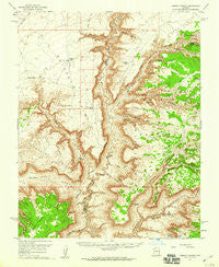
~ Jumpup Canyon AZ topo map, 1:62500 scale, 15 X 15 Minute, Historical, 1957, updated 1960
Jumpup Canyon, Arizona, USGS topographic map dated 1957.
Includes geographic coordinates (latitude and longitude). This topographic map is suitable for hiking, camping, and exploring, or framing it as a wall map.
Printed on-demand using high resolution imagery, on heavy weight and acid free paper, or alternatively on a variety of synthetic materials.
Topos available on paper, Waterproof, Poly, or Tyvek. Usually shipping rolled, unless combined with other folded maps in one order.
- Product Number: USGS-5548118
- Free digital map download (high-resolution, GeoPDF): Jumpup Canyon, Arizona (file size: 10 MB)
- Map Size: please refer to the dimensions of the GeoPDF map above
- Weight (paper map): ca. 55 grams
- Map Type: POD USGS Topographic Map
- Map Series: HTMC
- Map Verison: Historical
- Cell ID: 55921
- Scan ID: 314709
- Imprint Year: 1960
- Woodland Tint: Yes
- Aerial Photo Year: 1955
- Field Check Year: 1957
- Datum: NAD27
- Map Projection: Polyconic
- Map published by United States Geological Survey
- Map Language: English
- Scanner Resolution: 600 dpi
- Map Cell Name: Jumpup Canyon
- Grid size: 15 X 15 Minute
- Date on map: 1957
- Map Scale: 1:62500
- Geographical region: Arizona, United States
Neighboring Maps:
All neighboring USGS topo maps are available for sale online at a variety of scales.
Spatial coverage:
Topo map Jumpup Canyon, Arizona, covers the geographical area associated the following places:
- Dinner Pockets Trick Tank - Kanab-North Mine - Jumpup Cabin - Gunsight Canyon - Rock Canyon - Gunsight Tank - Slide Spring - Pine Hollow - Wildband Spring - Grama Canyon - Jumpup Point - Pigeon Point - Wildband Canyon - Willow Canyon - Water Canyon Catchment - Mountain Sheep Spring - The Gooseneck - Bulrush Point - Little Spring Tank - Box Elder Spring - Pigeon Mine - White Spring - Slide Canyon - Swapp Tank - Little Spring Canyon - Big Cove Tank - Burnt Canyon Point - Deer Trail Tank - Little Spring Trick Tank - White Pockets Canyon - Slide Elbow Tank - Hack Canyon - Jumpup Tank - Bone Hollow - Rock Spring - Horse Spring - Willow Point - Bitter Spring - Faver Tank - Horse Canyon - Lower Jumpup Spring - Pigeon Spring - Buckhorn Point - Buckhorn Tank - Divide Tank - Jensen Trick Tank - Horse Spring Point - Lower Cottonwood Spring - Jumpup Trick Tank - Snake Gulch - Cottonwood Spring - Willow Spring - Jensen Canyon - Kwagunt Hollow - Findlay Tank - Indian Hollow - Grama Spring - Sunshine Point - Dinner Pockets Canyon - Sowats Canyon - Meeks Reservoir - Kanab Creek Wilderness - Pigeon Canyon - Jumpup Divide - Goose Neck Trick Tank - Willow Spring - Sowats Point - Lawson Canyon - Horsespring Tank - Water Canyon Point - Jumpup Spring - Sunshine Point Catchment - Horse Spring Trick Tank - Gunsight Point - Water Canyon - Chamberlain Canyon - Little Spring - Rock Canyon Point - Big Cove Canyon - Slide Point - Upper Cottonwood Spring
- Map Area ID: AREA36.7536.5-112.75-112.5
- Northwest corner Lat/Long code: USGSNW36.75-112.75
- Northeast corner Lat/Long code: USGSNE36.75-112.5
- Southwest corner Lat/Long code: USGSSW36.5-112.75
- Southeast corner Lat/Long code: USGSSE36.5-112.5
- Northern map edge Latitude: 36.75
- Southern map edge Latitude: 36.5
- Western map edge Longitude: -112.75
- Eastern map edge Longitude: -112.5


