
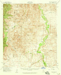
~ Happy Valley AZ topo map, 1:62500 scale, 15 X 15 Minute, Historical, 1958, updated 1959
Happy Valley, Arizona, USGS topographic map dated 1958.
Includes geographic coordinates (latitude and longitude). This topographic map is suitable for hiking, camping, and exploring, or framing it as a wall map.
Printed on-demand using high resolution imagery, on heavy weight and acid free paper, or alternatively on a variety of synthetic materials.
Topos available on paper, Waterproof, Poly, or Tyvek. Usually shipping rolled, unless combined with other folded maps in one order.
- Product Number: USGS-5548026
- Free digital map download (high-resolution, GeoPDF): Happy Valley, Arizona (file size: 9 MB)
- Map Size: please refer to the dimensions of the GeoPDF map above
- Weight (paper map): ca. 55 grams
- Map Type: POD USGS Topographic Map
- Map Series: HTMC
- Map Verison: Historical
- Cell ID: 55055
- Scan ID: 314657
- Imprint Year: 1959
- Woodland Tint: Yes
- Field Check Year: 1958
- Survey Year: 1943
- Datum: NAD27
- Map Projection: Polyconic
- Map published by United States Geological Survey
- Map Language: English
- Scanner Resolution: 600 dpi
- Map Cell Name: Happy Valley
- Grid size: 15 X 15 Minute
- Date on map: 1958
- Map Scale: 1:62500
- Geographical region: Arizona, United States
Neighboring Maps:
All neighboring USGS topo maps are available for sale online at a variety of scales.
Spatial coverage:
Topo map Happy Valley, Arizona, covers the geographical area associated the following places:
- Mackenzie Tank - Cadillac Wash - Steel Trough Spring - Apodaca Cemetery - Buckhorn Canyon - Hells Gate - Cumaro Spring - The Narrows - Stansbury Ranch - Palomas Spring - Sycamore Spring - Ash Creek - Cement Dam Tank - Bear Spring - Redrock Creek - Dripping Spring - Redrock Tank - Redrock - Lower Spring - Buckhorn Spring - Juanuña Spring - Martinez Ranch - Iron Flat - Barney Ranch - Pachelo Ranch - Collins Wash - Wildhorse Mountain - Cold Spring - Bald Mountain - McCormick Canyon - Palomas Wash - Last Chance Ranch - Eagle Peak - Rock Pile Tank - Wino Tank - Gardner Mountain - Upper Tank - Canoa Spring - Twin Tanks - Tres Alamos Ranch - Cañon la Carne Spring - Gardner Canyon - Bear Spring - Clopton Ranch - Section Fourteen Well - Miller Ranch - Kelsey Canyon - Martinez Wash - Cumaro Canyon - Ashrama Ranch - Bear Creek - Mackenzie Ranch - Stone Tank - Sycamore Canyon - Miller Canyon - Secret Pasture - Sycamore Spring - Fresno Spring - Turkey Creek Trailhead - Cornfield Canyon - Willow Lake - Little Rincon Mountains - Grapevine Canyon - Paige Well - Miller Flat - Benson Division - White Cross Cemetery - Boulder Tank - Upper Spring - Mesquite Canyon Spring - Pacheco Wash - Hidden Pasture - East Tank - Galleta Flat - Singing Wind Ranch - Forest Hill - Fox Mountain - San Juan Hill - San Pedro Valley - Cement Dam - North Star Peak - San Juan Spring - Turkey Creek - Miller Creek Trailhead - Upper West Fork Spring - Alboyd Spring - Lechuguilla Peak - Cañon la Carne - Mesquite Canyon - Kiper Spring - Upper Mesquite Canyon Spring - Grapevine Spring - World University - Tres Alamos Wash - Driscoll Mountain - Diamond E Spring - Deer Creek - Happy Valley - Lower Turkey Creek Spring
- Map Area ID: AREA32.2532-110.5-110.25
- Northwest corner Lat/Long code: USGSNW32.25-110.5
- Northeast corner Lat/Long code: USGSNE32.25-110.25
- Southwest corner Lat/Long code: USGSSW32-110.5
- Southeast corner Lat/Long code: USGSSE32-110.25
- Northern map edge Latitude: 32.25
- Southern map edge Latitude: 32
- Western map edge Longitude: -110.5
- Eastern map edge Longitude: -110.25


