
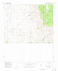
~ Guadalupe Canyon AZ topo map, 1:62500 scale, 15 X 15 Minute, Historical, 1958, updated 1980
Guadalupe Canyon, Arizona, USGS topographic map dated 1958.
Includes geographic coordinates (latitude and longitude). This topographic map is suitable for hiking, camping, and exploring, or framing it as a wall map.
Printed on-demand using high resolution imagery, on heavy weight and acid free paper, or alternatively on a variety of synthetic materials.
Topos available on paper, Waterproof, Poly, or Tyvek. Usually shipping rolled, unless combined with other folded maps in one order.
- Product Number: USGS-5548010
- Free digital map download (high-resolution, GeoPDF): Guadalupe Canyon, Arizona (file size: 5 MB)
- Map Size: please refer to the dimensions of the GeoPDF map above
- Weight (paper map): ca. 55 grams
- Map Type: POD USGS Topographic Map
- Map Series: HTMC
- Map Verison: Historical
- Cell ID: 54900
- Scan ID: 314646
- Imprint Year: 1980
- Woodland Tint: Yes
- Aerial Photo Year: 1956
- Field Check Year: 1958
- Datum: NAD27
- Map Projection: Polyconic
- Map published by United States Geological Survey
- Map Language: English
- Scanner Resolution: 600 dpi
- Map Cell Name: Guadalupe Canyon
- Grid size: 15 X 15 Minute
- Date on map: 1958
- Map Scale: 1:62500
- Geographical region: Arizona, United States
Neighboring Maps:
All neighboring USGS topo maps are available for sale online at a variety of scales.
Spatial coverage:
Topo map Guadalupe Canyon, Arizona, covers the geographical area associated the following places:
- Prospect Tank - Guadalupe Canyon - Bunk Robinson Peak - Cowboy Flat - Lazy J Ranch - Outlaw Mountain - Granite Tank - Cottonwood Creek School - McDonald Ranch - Taylor Ranch - Baker Spring - Guadalupe Spring - Indian Spring - Guadalupe Mountain - Lion Creek - Hog Ranch - Lee Howard Spring - Silvertip Mine - Cedar Spring - Swaggart Spring - Ledar Seep - Line V Seven Ranch - Bunk Robinson Spring - Pickhandle Tank - Miller Creek - Pickhandle Hills - Ledar Spring - Miller Spring - Hog Canyon Tank - Cottonwood Creek Cemetery - Spring of Contention - Hog Canyon - Maverick Spring - Blackwater Hole - Buck Robinson Wilderness Study Area - Eicks Spring - Hay Hollow Wash - Mormon Tanks - Cedar Tank - Sycamore Creek - Estes Canyon - Casper Spring Tank - Little Bunk Robinson Spring - Baker Canyon
- Map Area ID: AREA31.531.25-109.25-109
- Northwest corner Lat/Long code: USGSNW31.5-109.25
- Northeast corner Lat/Long code: USGSNE31.5-109
- Southwest corner Lat/Long code: USGSSW31.25-109.25
- Southeast corner Lat/Long code: USGSSE31.25-109
- Northern map edge Latitude: 31.5
- Southern map edge Latitude: 31.25
- Western map edge Longitude: -109.25
- Eastern map edge Longitude: -109


