
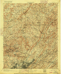
~ Birmingham AL topo map, 1:125000 scale, 30 X 30 Minute, Historical, 1907, updated 1916
Birmingham, Alabama, USGS topographic map dated 1907.
Includes geographic coordinates (latitude and longitude). This topographic map is suitable for hiking, camping, and exploring, or framing it as a wall map.
Printed on-demand using high resolution imagery, on heavy weight and acid free paper, or alternatively on a variety of synthetic materials.
Topos available on paper, Waterproof, Poly, or Tyvek. Usually shipping rolled, unless combined with other folded maps in one order.
- Product Number: USGS-5542689
- Free digital map download (high-resolution, GeoPDF): Birmingham, Alabama (file size: 12 MB)
- Map Size: please refer to the dimensions of the GeoPDF map above
- Weight (paper map): ca. 55 grams
- Map Type: POD USGS Topographic Map
- Map Series: HTMC
- Map Verison: Historical
- Cell ID: 65005
- Scan ID: 305812
- Imprint Year: 1916
- Survey Year: 1905
- Datum: Unstated
- Map Projection: Unstated
- Map published by United States Geological Survey
- Map Language: English
- Scanner Resolution: 600 dpi
- Map Cell Name: Birmingham
- Grid size: 30 X 30 Minute
- Date on map: 1907
- Map Scale: 1:125000
- Geographical region: Alabama, United States
Neighboring Maps:
All neighboring USGS topo maps are available for sale online at a variety of scales.
Spatial coverage:
Topo map Birmingham, Alabama, covers the geographical area associated the following places:
- Moss Rock - East Trussville (historical) - Greenleas Heights - Argo - Old Leeds Forest - Arkadelphia - Ayres Estates - Oak Park - Springdale - New Castle - Watseka (historical) - Sun Valley - High Rock - Westwood Trailer Court - Countryside Estates - Oakhurst - Cotton Ridge - Innsbrooke - Owenton - Seloca - Roper - Vulcan City - Confederate Estates - Berkley Hills - Dogwood Estates - East Thomas - Cahaba Village - Five Points East - Coalburg - Weems - Locust Fork - Hayes Highland - Robbins Crossroads - Harriman Park - Linton - Adamsville - Glendale - Braggsville - Country Haven - Roebuck Springs - Hampton Place - Armstead - Sayre - Near Acres Estates - Queenstown - Glencoe - Gable Cove - Acipcoville - Hunters Hill - Markeeta - Adville - Mulga Mine - Upper Coalburg - Euclid Estates - Village Creek Junction - Kingsway Terrace - Bel Air - Von Dale - Echo Hills - Irondale - Red Wine - Union Grove - Springdale - Huffman - Godwin Estates - Elyton - Washington Heights - Oak Lawn - Valley Crest Estates - Country Estates - Vulcan - Graystone - Vanderbilt - Dale (historical) - Killough Springs - Nottingham - Bagley Meadows - Forestdale by the Brook - Edgewater Junction - Cherokee Bend - Brentwood Hills - Ayres - Lewisburg - Mulga - Roebuck Plaza - Jefferson Hills - Gurley - Clear Springs - West Sayre - Selfville - Fernwood Estates - Tutwiler Farm - Hundred Oaks - Linn Crossing - Avondale - Sherman Heights - Morris - Columbus - Littleton - Sulpher Springs
- Map Area ID: AREA3433.5-87-86.5
- Northwest corner Lat/Long code: USGSNW34-87
- Northeast corner Lat/Long code: USGSNE34-86.5
- Southwest corner Lat/Long code: USGSSW33.5-87
- Southeast corner Lat/Long code: USGSSE33.5-86.5
- Northern map edge Latitude: 34
- Southern map edge Latitude: 33.5
- Western map edge Longitude: -87
- Eastern map edge Longitude: -86.5


