
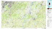
~ Birmingham South AL topo map, 1:100000 scale, 30 X 60 Minute, Historical, 1984, updated 1988
Birmingham South, Alabama, USGS topographic map dated 1984.
Includes geographic coordinates (latitude and longitude). This topographic map is suitable for hiking, camping, and exploring, or framing it as a wall map.
Printed on-demand using high resolution imagery, on heavy weight and acid free paper, or alternatively on a variety of synthetic materials.
Topos available on paper, Waterproof, Poly, or Tyvek. Usually shipping rolled, unless combined with other folded maps in one order.
- Product Number: USGS-5542587
- Free digital map download (high-resolution, GeoPDF): Birmingham South, Alabama (file size: 33 MB)
- Map Size: please refer to the dimensions of the GeoPDF map above
- Weight (paper map): ca. 55 grams
- Map Type: POD USGS Topographic Map
- Map Series: HTMC
- Map Verison: Historical
- Cell ID: 67142
- Scan ID: 305755
- Imprint Year: 1988
- Woodland Tint: Yes
- Aerial Photo Year: 1981
- Edit Year: 1984
- Datum: NAD27
- Map Projection: Universal Transverse Mercator
- Map published by United States Geological Survey
- Map Language: English
- Scanner Resolution: 600 dpi
- Map Cell Name: Birmingham South
- Grid size: 30 X 60 Minute
- Date on map: 1984
- Map Scale: 1:100000
- Geographical region: Alabama, United States
Neighboring Maps:
All neighboring USGS topo maps are available for sale online at a variety of scales.
Spatial coverage:
Topo map Birmingham South, Alabama, covers the geographical area associated the following places:
- Cloverdale - Cahaba River Estates - Minniesville - Longbrook Estates - Hyde Park - Valentine - Circle Heights - Williamsburg - Rocky Bridge - Stewartville - Midfield - Brownville - Fountainrun (historical) - Glen Forest - Powderly - Brecon - Roosevelt - Countrywood Highlands - Ivy Glenn - Sylacauga - Gage - Windover - Southpointe - Smelley - Interurban Heights - Lipscomb - Rosemont - Renfroe - Shannon Glen - Mignon - Helena - Childersburg - Gantts Quarry - Bessemer - Monte Bello - Spring Creek - Cedarbrook Forest - Panorama - The Moon - Oak Hills - Boaz Corner - Fair Park - Westbrook Trace - Havenview - Lakewood Estate - Westover - Southwood - Highland Forest - Russet Woods - Fairfield - Oldfield - Valdawood - Chico - Briarfield - Meadow Green - Lakewood Hills - Navajo Pines - Eastern Valley - Cedar Crest - Harlem Heights - Westfield - Lochridge - Timber Ridge - West Lake Highlands - Blue Creek Junction - Lake Purdy - Lakeview Park - Meadowbrook - Whispering Oaks - Valley Forge - Dunavant - Hickory Ridge Estates - Homestead - Lake Joy - Liberty Hill - Rocky Ridge - Deerhurst - Midway - Polo Trace - Skeggs Crossroads - Vestavia Hills Estates - Indian Hill - Longleaf - Vincent - Reubenville - Pauls Hill - Loch Haven - Bon-Air - Watkins Glen - Ivanhoe - Biltmore Estates - Moores Crossroads - Gurnee Junction - Comerdale - Lakeview Estates - Jonesville - Shady Acres Estates - Hepzibah - Central Park Highlands - Mallard Point
- Map Area ID: AREA33.533-87-86
- Northwest corner Lat/Long code: USGSNW33.5-87
- Northeast corner Lat/Long code: USGSNE33.5-86
- Southwest corner Lat/Long code: USGSSW33-87
- Southeast corner Lat/Long code: USGSSE33-86
- Northern map edge Latitude: 33.5
- Southern map edge Latitude: 33
- Western map edge Longitude: -87
- Eastern map edge Longitude: -86


