
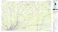
~ Birmingham North AL topo map, 1:100000 scale, 30 X 60 Minute, Historical, 1984, updated 1985
Birmingham North, Alabama, USGS topographic map dated 1984.
Includes geographic coordinates (latitude and longitude). This topographic map is suitable for hiking, camping, and exploring, or framing it as a wall map.
Printed on-demand using high resolution imagery, on heavy weight and acid free paper, or alternatively on a variety of synthetic materials.
Topos available on paper, Waterproof, Poly, or Tyvek. Usually shipping rolled, unless combined with other folded maps in one order.
- Product Number: USGS-5542581
- Free digital map download (high-resolution, GeoPDF): Birmingham North, Alabama (file size: 24 MB)
- Map Size: please refer to the dimensions of the GeoPDF map above
- Weight (paper map): ca. 55 grams
- Map Type: POD USGS Topographic Map
- Map Series: HTMC
- Map Verison: Historical
- Cell ID: 67141
- Scan ID: 305752
- Imprint Year: 1985
- Woodland Tint: Yes
- Aerial Photo Year: 1981
- Edit Year: 1984
- Datum: NAD27
- Map Projection: Universal Transverse Mercator
- Planimetric: Yes
- Map published by United States Geological Survey
- Map Language: English
- Scanner Resolution: 600 dpi
- Map Cell Name: Birmingham North
- Grid size: 30 X 60 Minute
- Date on map: 1984
- Map Scale: 1:100000
- Geographical region: Alabama, United States
Neighboring Maps:
All neighboring USGS topo maps are available for sale online at a variety of scales.
Spatial coverage:
Topo map Birmingham North, Alabama, covers the geographical area associated the following places:
- Sunnyside - Park Place - Deavers Town - Woody Acres - Owenton - Gardendale - Candlewood Lakes - Ingle Terrace - Wolf Creek - Jefferson Hills - Longview Mobile Home Park - Brompton - Roebuck Forest - Linton - Womack (historical) - Brookmont - Riverside - Eastaboga - Hunting Ridge - Scarlet Town - Smoke Rise - Appalachian - Mountaindale - Inglenook - Country Estates - McCombs - Hardwick - Moody - Woodlawn Heights - Ragland - Echo Hills - Whitney Junction - Ottery - Paragon Estates - Davis Acres - Hundred Oaks - Exum - Roebuck - Dogwood Estates - Chulavista - Zion City - Dry Valley - South Highlands - Russell Heights - Pinson - Scott City - Brentwood - Mount Olive - Harriman Park - Pleasant Grove - Lester - Locust Fork - East Thomas Gardens - East Thomas - Frances Heights - Central Highlands - Bremen - Armstead - Fairfield - Morningside - Nyota - Holiday Gardens - Longview Estates - Embry Bend - Cahaba Cove - Tuxedo Heights - Whitney - Trussville Manor - Hayes Highland - Gum Springs (historical) - Bradford - Sherwood Shores - Thermal (historical) - Ridgewood Estates - Hood - Columbus - West Ensley - Etowahton (historical) - Nix (historical) - Rolling Hills - Franklin Gardens - Fountain Heights - Saint Clair Forest - Beltona - North Lake Park - Hendrick Mill - Near Acres Estates - Bangor - Gallant - East Boyles - Avon Park - Vanderbilt - Ensley Highlands - Moss Rock - Lakewood - Fernwood Estates - Lawley - Oakhurst - East Birmingham - Sun Valley
- Map Area ID: AREA3433.5-87-86
- Northwest corner Lat/Long code: USGSNW34-87
- Northeast corner Lat/Long code: USGSNE34-86
- Southwest corner Lat/Long code: USGSSW33.5-87
- Southeast corner Lat/Long code: USGSSE33.5-86
- Northern map edge Latitude: 34
- Southern map edge Latitude: 33.5
- Western map edge Longitude: -87
- Eastern map edge Longitude: -86


