
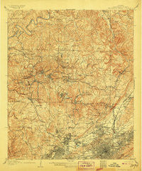
~ Birmingham Special AL topo map, 1:62500 scale, 15 X 15 Minute, Historical, 1906
Birmingham Special, Alabama, USGS topographic map dated 1906.
Includes geographic coordinates (latitude and longitude). This topographic map is suitable for hiking, camping, and exploring, or framing it as a wall map.
Printed on-demand using high resolution imagery, on heavy weight and acid free paper, or alternatively on a variety of synthetic materials.
Topos available on paper, Waterproof, Poly, or Tyvek. Usually shipping rolled, unless combined with other folded maps in one order.
- Product Number: USGS-5542207
- Free digital map download (high-resolution, GeoPDF): Birmingham Special, Alabama (file size: 12 MB)
- Map Size: please refer to the dimensions of the GeoPDF map above
- Weight (paper map): ca. 55 grams
- Map Type: POD USGS Topographic Map
- Map Series: HTMC
- Map Verison: Historical
- Cell ID: 51408
- Scan ID: 305506
- Survey Year: 1904
- Datum: Unstated
- Map Projection: Unstated
- Special Map: Yes
- Map published by United States Geological Survey
- Map Language: English
- Scanner Resolution: 600 dpi
- Map Cell Name: Birmingham Coal District
- Grid size: 15 X 15 Minute
- Date on map: 1906
- Map Scale: 1:62500
- Geographical region: Alabama, United States
Neighboring Maps:
All neighboring USGS topo maps are available for sale online at a variety of scales.
Spatial coverage:
Topo map Birmingham Special, Alabama, covers the geographical area associated the following places:
- Tarrant Garden Estates - Shadyside - Mulga - Brookside - Tuxedo Heights - Fultondale Estates - Upper Coalburg - Watson - Sayre - Ketona - Acipcoville - Sherwood Hills - Boyles Highlands - Pratt City - Parker Heights - Frances Heights - Danville - Graysville Heights - Woodlawn - Daisey City - Bartonville - Mount Olive - Hooper City - Bendale - Frenchtown - Avon Park - Crumley Chapel - Fulton Springs - Redmont Park - Harriman Park - West Sayre - Gardendale - Mountain Park - Red Wine - Westwood Garden Estates - Norwood - Washington Heights - Five Points South - Douglasville - New Castle - Exum - East Boyles - Hayes Highland - Daisey City Trailer Park - Owenton - Republic - Birmingham - Chetopa - Village Creek - Vanderbilt - Union Grove - Oakwood - Avondale - Morris - Sayreton - Ingle Terrace - Oak Park - Jet - Inglenook - Meadwood Heights - Maytown - Dogtown - Vulcan City - Graysons Addition - Edgewater - Cunningham (historical) - Oakhurst - Falls Junction - Altamont Park - Minor - Westwood Trailer Court - Graysville - Forest Park - Thomas - Grays Gardens - Ensley - Oak Forest - Fieldstown - Greenleas Heights - Sherman Heights - Wylam - Crestline Heights - Hillview - Sunset Mountain - Forestdale Mobile Home Park - Pinkney City - Plain View - Humoro - Crocker Junction - Walker Chapel - Forest View Estates - Westwood - Midway - Edgewater Junction - Magnolia Heights - Brents Cross Roads - Fairfield - Black Creek - Merrywood - Hillcrest Estates
- Map Area ID: AREA33.7533.5-87-86.75
- Northwest corner Lat/Long code: USGSNW33.75-87
- Northeast corner Lat/Long code: USGSNE33.75-86.75
- Southwest corner Lat/Long code: USGSSW33.5-87
- Southeast corner Lat/Long code: USGSSE33.5-86.75
- Northern map edge Latitude: 33.75
- Southern map edge Latitude: 33.5
- Western map edge Longitude: -87
- Eastern map edge Longitude: -86.75


