
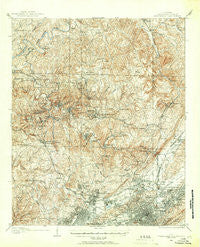
~ Birmingham Coal District AL topo map, 1:62500 scale, 15 X 15 Minute, Historical, 1904, updated 1967
Birmingham Coal District, Alabama, USGS topographic map dated 1904.
Includes geographic coordinates (latitude and longitude). This topographic map is suitable for hiking, camping, and exploring, or framing it as a wall map.
Printed on-demand using high resolution imagery, on heavy weight and acid free paper, or alternatively on a variety of synthetic materials.
Topos available on paper, Waterproof, Poly, or Tyvek. Usually shipping rolled, unless combined with other folded maps in one order.
- Product Number: USGS-5542199
- Free digital map download (high-resolution, GeoPDF): Birmingham Coal District, Alabama (file size: 13 MB)
- Map Size: please refer to the dimensions of the GeoPDF map above
- Weight (paper map): ca. 55 grams
- Map Type: POD USGS Topographic Map
- Map Series: HTMC
- Map Verison: Historical
- Cell ID: 51408
- Scan ID: 305502
- Imprint Year: 1967
- Survey Year: 1904
- Datum: NAD27
- Map Projection: Polyconic
- Map published by United States Geological Survey
- Map Language: English
- Scanner Resolution: 600 dpi
- Map Cell Name: Birmingham Coal District
- Grid size: 15 X 15 Minute
- Date on map: 1904
- Map Scale: 1:62500
- Geographical region: Alabama, United States
Neighboring Maps:
All neighboring USGS topo maps are available for sale online at a variety of scales.
Spatial coverage:
Topo map Birmingham Coal District, Alabama, covers the geographical area associated the following places:
- Edgewater Junction - Birmingham - Hillcrest Estates - Chetopa - Village Creek Junction - Acipcoville - Oak Forest - Bendale - Kingston - Littleton - Forest View Estates - Meadwood Heights - Merrywood - Inglenook - Dogtown - East Thomas Gardens - Highland Residence Park - Hillview - Crestline Heights - Mountain Brook - Springdale - Hobson - Sherman Heights - Oak Lawn - Fultondale - Mountain Park - Magnolia Heights - Cardiff - Harriman Park - Frenchtown - Oakhurst - Scarlet Town - Forestdale - East Birmingham - Tarrant - East Boyles - Boyles Highlands - West Ensley - Park Place - Bay View - The Drifttracks - Zion Heights - Edgewater - Westwood Garden Estates - Greenleas Heights - Morris - Oak Park - Crockard Junction - Elyton - Majestic - Ensley - North Birmingham - Fieldstown - Watson - Humoro - Sunset Mountain - Black Creek - Crocker Junction - Linn Crossing - Mineral Springs - Franklin Gardens - Longview Mobile Home Park - Woodlawn - Pinkney City - Graysville Heights - Parker Heights - West Sayre - Norwood - Westwood - Little Italy - Sayre - Westwood Trailer Court - Pratt City - Glendale - Sayreton - Avondale - Ketona - Upper Coalburg - Jefferson Hills - Mulga Mine - New Castle - East Thomas - New Town - Docena - Brookside - Alden - Midway - Walker Chapel - Crumley Chapel - Washington Heights - Maytown - Coalburg - Grays Gardens - Lewisburg - Sherwood Hills - Redmont Park - Gardendale - Fulton Springs - Vulcan - Tarrant Heights
- Map Area ID: AREA33.7533.5-87-86.75
- Northwest corner Lat/Long code: USGSNW33.75-87
- Northeast corner Lat/Long code: USGSNE33.75-86.75
- Southwest corner Lat/Long code: USGSSW33.5-87
- Southeast corner Lat/Long code: USGSSE33.5-86.75
- Northern map edge Latitude: 33.75
- Southern map edge Latitude: 33.5
- Western map edge Longitude: -87
- Eastern map edge Longitude: -86.75


