
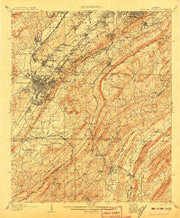
~ Bessemer Special AL topo map, 1:62500 scale, 15 X 15 Minute, Historical, 1907
Bessemer Special, Alabama, USGS topographic map dated 1907.
Includes geographic coordinates (latitude and longitude). This topographic map is suitable for hiking, camping, and exploring, or framing it as a wall map.
Printed on-demand using high resolution imagery, on heavy weight and acid free paper, or alternatively on a variety of synthetic materials.
Topos available on paper, Waterproof, Poly, or Tyvek. Usually shipping rolled, unless combined with other folded maps in one order.
- Product Number: USGS-5542191
- Free digital map download (high-resolution, GeoPDF): Bessemer Special, Alabama (file size: 11 MB)
- Map Size: please refer to the dimensions of the GeoPDF map above
- Weight (paper map): ca. 55 grams
- Map Type: POD USGS Topographic Map
- Map Series: HTMC
- Map Verison: Historical
- Cell ID: 51255
- Scan ID: 305491
- Survey Year: 1905
- Datum: Unstated
- Map Projection: Unstated
- Special Map: Yes
- Map published by United States Geological Survey
- Map Language: English
- Scanner Resolution: 600 dpi
- Map Cell Name: Bessemer Iron District
- Grid size: 15 X 15 Minute
- Date on map: 1907
- Map Scale: 1:62500
- Geographical region: Alabama, United States
Neighboring Maps:
All neighboring USGS topo maps are available for sale online at a variety of scales.
Spatial coverage:
Topo map Bessemer Special, Alabama, covers the geographical area associated the following places:
- Tangle Creek - Montreat - Rolling Ridge - Thomas Acres - Cahaba Valley Estates - Wilkes - Southridge - Imperial Forest - Hopewell - Pauls Hill - Brighton - Ensley Junction - Beverly Station - Madison - Jonesboro - Vesclub Estates - Crossgate - Millbrook Estates - Valley Station - Park Courts - Spaulding - Highlands - Elvira - Southwood - Paramount - Hardy - Genery - Green View Estates - Ivanhoe - Blue Creek Junction - Longleaf - Phillips Estates - Fox Trace - Kingwood - English Village - Southlake - Weeping Oaks - Monte D'Oro - Fox Haven - Powderly Hills - Chapel Hill - Edgewood - Hudson Gardens - Plantation Point - Watkins Glen - Minniesville - Glenview - Laurel Estates - Surrey Hill - Greenwood - Fairfield - Mobile Junction - Helena - Woodward - Anns Trailer Court - Lakewood Estate - Dolonar - Garywood - Edgemoor Estates - Shannon - Eastern Valley - Woodmeadows - Summit Farm - Wisteria Commons - Midfield - Dearing Downs - Vestavia Lake - Tacoa - Lakewood Hills - Bush - Hickory Ridge Estates - Mountain Brook Village - Fungo Hollow - Cottage Hill - Brickyard Junction - Hickory Grove - Cloverdale - Huntington Park - Interurban Heights - Camden Place - Ivy Glenn - Chandalar South - Homewood - Highland Crest - Stonebrook Park - Edgemont Park - Belwood - Shannon Glen - Glen Hills - Polo Trace - Forest Hills - Broadmoor - Port South - Deer Springs Estates - Hollywood - Indian Springs Village - Glen Iris - Bessemer Trailer Park - Hueytown Crest - Monte-Sano
- Map Area ID: AREA33.533.25-87-86.75
- Northwest corner Lat/Long code: USGSNW33.5-87
- Northeast corner Lat/Long code: USGSNE33.5-86.75
- Southwest corner Lat/Long code: USGSSW33.25-87
- Southeast corner Lat/Long code: USGSSE33.25-86.75
- Northern map edge Latitude: 33.5
- Southern map edge Latitude: 33.25
- Western map edge Longitude: -87
- Eastern map edge Longitude: -86.75


