
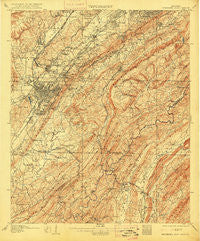
~ Bessemer Iron District AL topo map, 1:62500 scale, 15 X 15 Minute, Historical, 1907, updated 1915
Bessemer Iron District, Alabama, USGS topographic map dated 1907.
Includes geographic coordinates (latitude and longitude). This topographic map is suitable for hiking, camping, and exploring, or framing it as a wall map.
Printed on-demand using high resolution imagery, on heavy weight and acid free paper, or alternatively on a variety of synthetic materials.
Topos available on paper, Waterproof, Poly, or Tyvek. Usually shipping rolled, unless combined with other folded maps in one order.
- Product Number: USGS-5542187
- Free digital map download (high-resolution, GeoPDF): Bessemer Iron District, Alabama (file size: 11 MB)
- Map Size: please refer to the dimensions of the GeoPDF map above
- Weight (paper map): ca. 55 grams
- Map Type: POD USGS Topographic Map
- Map Series: HTMC
- Map Verison: Historical
- Cell ID: 51255
- Scan ID: 305496
- Imprint Year: 1915
- Survey Year: 1905
- Datum: Unstated
- Map Projection: Unstated
- Map published by United States Geological Survey
- Map Language: English
- Scanner Resolution: 600 dpi
- Map Cell Name: Bessemer Iron District
- Grid size: 15 X 15 Minute
- Date on map: 1907
- Map Scale: 1:62500
- Geographical region: Alabama, United States
Neighboring Maps:
All neighboring USGS topo maps are available for sale online at a variety of scales.
Spatial coverage:
Topo map Bessemer Iron District, Alabama, covers the geographical area associated the following places:
- Pineland Park - Grasselli - Hudson Grove - Lakewood Estate - Greenwood - Cedar Crest - Keystone - Heatherwood - Parkwood Hills - Woodward Estates - Vestavia Forest - Industrial City - Rocky Ridge - Port South - Ensley Junction - East Brighton - Regent Forest Estates - West End - West Highlands - English Village - Altadena Forest Estates - Vestavia Hills Estates - Indian Springs Village - Pine Crest - Hueytown Crest - Buena Vista Highlands - Fairfield Village - Crossgate - Cullom Place - Hickory Ridge Estates - Edgewood - Winetka - Powderly Hills - Windsor Highlands - Brooklane Place - Belle Terre - Oak Hills - Huntington Park - Windover - Wenonah - Hickory Ridge Estates - Hunters Glen (historical) - Havenview - Navajo Hills - Summit Farm - Cottage Hill - Chestnut Ridge - Dolly Ridge Estates - Walnut Grove - Fox Haven - Wilkes - Roebuck - Lake Drive Estates - New Hill - Thomas Acres - Camden Place - Beacon Hills - Royal Oaks - Plantation Point - Cedarbrook Forest - Bon-Air - Eastern Valley - Crest Estates - Hopewell - Biltmore Estates - Jones Valley - Gentilly Forest - Rosedale - Gordon Heights - Vesthaven Estates - Ishkooda - Rolling Ridge - Countrywood Highlands - Weeping Oaks - Woodmont - Laurel Estates - Mountain Brook Village - Timber Ridge - Park Place - Wooddale - Mountain Oaks - Glen Oaks - Mayfair - Woodward Junction - Westfield - Bessemer Trailer Park - Central Park Highlands - Country Club Highlands - Martins - Collins - Lakewood Hills - Arbor Crossing - Grove Park - Vestavia Lake - Hillman - Old Jonesboro - Vestridge - Pauls Hill - Glen Hills - Abington Green
- Map Area ID: AREA33.533.25-87-86.75
- Northwest corner Lat/Long code: USGSNW33.5-87
- Northeast corner Lat/Long code: USGSNE33.5-86.75
- Southwest corner Lat/Long code: USGSSW33.25-87
- Southeast corner Lat/Long code: USGSSE33.25-86.75
- Northern map edge Latitude: 33.5
- Southern map edge Latitude: 33.25
- Western map edge Longitude: -87
- Eastern map edge Longitude: -86.75


