
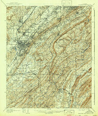
~ Bessemer Iron District AL topo map, 1:62500 scale, 15 X 15 Minute, Historical, 1907, updated 1942
Bessemer Iron District, Alabama, USGS topographic map dated 1907.
Includes geographic coordinates (latitude and longitude). This topographic map is suitable for hiking, camping, and exploring, or framing it as a wall map.
Printed on-demand using high resolution imagery, on heavy weight and acid free paper, or alternatively on a variety of synthetic materials.
Topos available on paper, Waterproof, Poly, or Tyvek. Usually shipping rolled, unless combined with other folded maps in one order.
- Product Number: USGS-5542183
- Free digital map download (high-resolution, GeoPDF): Bessemer Iron District, Alabama (file size: 12 MB)
- Map Size: please refer to the dimensions of the GeoPDF map above
- Weight (paper map): ca. 55 grams
- Map Type: POD USGS Topographic Map
- Map Series: HTMC
- Map Verison: Historical
- Cell ID: 51255
- Scan ID: 305494
- Imprint Year: 1942
- Survey Year: 1905
- Datum: Unstated
- Map Projection: Polyconic
- Map published by United States Geological Survey
- Map Language: English
- Scanner Resolution: 600 dpi
- Map Cell Name: Bessemer Iron District
- Grid size: 15 X 15 Minute
- Date on map: 1907
- Map Scale: 1:62500
- Geographical region: Alabama, United States
Neighboring Maps:
All neighboring USGS topo maps are available for sale online at a variety of scales.
Spatial coverage:
Topo map Bessemer Iron District, Alabama, covers the geographical area associated the following places:
- Highlands - Hunters Glen (historical) - Walnut Grove - Regent Forest Estates - Tanglewood - Oxmoor - Lake Shore Estates - Vestavia Lake - Raimund - Laceys Chapel - Coalmont - Highland Crest - Jonesboro - Wenonah - Chimney Hills - Green View Estates - Shady Brook Mobile Home Park - Timbercrest - Indian Hills - Pineland Park - Hudson Grove - Cherokee Beach - Southpointe - Millbrook Estates - Buena Vista Highlands - Spaulding - Rocky Ridge Manor - Old Jonesboro - Grove Park - Quail Run - Cahaba Valley Estates - Fairfield Village - Cherokee Forest - Dearing Downs - Woodward - Fox Haven - Pleasant Hill - Vestbrook Trace - Mountain Branch Estates - Ivanhoe - Mountain Brook Village - Mars Hill - Hickory Ridge Estates - Havenview - Cullom Place - Rice - Interurban Heights - Cedar Crest - Hidden Ridge - Parkwood - Vestridge - Vineland Park - Vestavia Hills Estates - High Point - Mossboro - Genery - Tacoa - Forest Ridge Estates - Midfield - Hollywood - Jones Valley - Brownville - Mill Run - Lochridge - Lakeview Park - Industrial City - Lakewood Estate - Watkins Glen - English Village - Scottrock - Greenwood - Parkwood Hills - Scott Crest Subdivision - Wooddale - Huntington Park - Arbor Crossing - Polo Trace - Oakwood - Pleasant Grove - Summit Farm - Timber Ridge - Panorama - Crescent Heights - Lakeview Estates - Laurel Estates - Mason City - Tarpley - Verdue Knolls - Patton Chapel - Indian Springs Ranch - Shannon - Windover - Mountain Woods Park - Vesclub Estates - Country Club Highlands - Fairfield Highlands - Huntington Park - Indian Lake Estates - Dolonar - Southridge
- Map Area ID: AREA33.533.25-87-86.75
- Northwest corner Lat/Long code: USGSNW33.5-87
- Northeast corner Lat/Long code: USGSNE33.5-86.75
- Southwest corner Lat/Long code: USGSSW33.25-87
- Southeast corner Lat/Long code: USGSSE33.25-86.75
- Northern map edge Latitude: 33.5
- Southern map edge Latitude: 33.25
- Western map edge Longitude: -87
- Eastern map edge Longitude: -86.75


