
~ Portland ME topo map, 1:100000 scale, 30 X 60 Minute, Historical, 1985, updated 1988
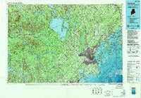
Portland, Maine, USGS topographic map dated 1985.
Includes geographic coordinates (latitude and longitude). This topographic map is suitable for hiking, camping, and exploring, or framing it as a wall map.
Printed on-demand using high resolution imagery, on heavy weight and acid free paper, or alternatively on a variety of synthetic materials.
Topos available on paper, Waterproof, Poly, or Tyvek. Usually shipping rolled, unless combined with other folded maps in one order.
- Product Number: USGS-5537411
- Free digital map download (high-resolution, GeoPDF): Portland, Maine (file size: 32 MB)
- Map Size: please refer to the dimensions of the GeoPDF map above
- Weight (paper map): ca. 55 grams
- Map Type: POD USGS Topographic Map
- Map Series: HTMC
- Map Verison: Historical
- Cell ID: 68183
- Scan ID: 808181
- Imprint Year: 1988
- Woodland Tint: Yes
- Photo Inspection Year: 1988
- Aerial Photo Year: 1982
- Edit Year: 1988
- Datum: NAD27
- Map Projection: Universal Transverse Mercator
- Map published by United States Geological Survey
- Map Language: English
- Scanner Resolution: 508 dpi
- Map Cell Name: Portland
- Grid size: 30 X 60 Minute
- Date on map: 1985
- Map Scale: 1:100000
- Geographical region: Maine, United States
Neighboring Maps:
All neighboring USGS topo maps are available for sale online at a variety of scales.
Spatial coverage:
Topo map Portland, Maine, covers the geographical area associated the following places:
- West Falmouth Corner - South Effingham - Grand Beach - East Waterboro - Shaker Village - North Waterboro - Bar Mills - East Limington - Boothbay Park - Great Diamond Island Landing - Porter - Cliff Island - Cliff Island Landing - West Denmark - Sagamore Village - Foggs Corner - Bunganuc Landing - Windham Center - Intervale - North Shapleigh - East Deering - Frye Island - Long Island - West Brownfield - Edes Falls - Chadbournes Mills - Meeting House Hill - Windham Hill - North Sebago - Riverton - Higgins Beach - South Windham - West Scarborough - Waterboro - East Baldwin Mattocks Station - Knightville - New Boston - Pleasantdale - East Parsonsfield - Sunset Landing - Fort Preble - Todds Corners - West Cumberland - Shaw Mills - South Portland Gardens - Convene - Tory Hill - Sebago Lake - Woodman - Pleasant Hill - West Buxton - Durgintown - Denmark - Glantz Corner - Mosher Corner - White Rock - Broadview Park - Walnut Hill - West Durham - Douglas Hill - Great Falls (historical) - Royal Junction - North Gorham - South Bridgton - Goodwins Mills - Tylers Corner - Dog Corner - Portland - Dow Corner - Sandy Brook - Highland Lake - North Falmouth - Richville - Emerys Corner - Limerick - Lisbon Falls - Stroudwater - Hollis Center - Popeville - New Gloucester - Nasons Corner - Hiram - Groveville - Shady Nook - Maplewood - Mast Landing - South Freeport - Old Orchard Beach - Upper Village (historical) - Ossipee Mills - Roberts Corner - Kimballs Corner - Thornton Heights - Union Falls - North Gray - Morrills Corner - Danish Village (historical) - Porterfield - Long Beach - Pine Point
- Map Area ID: AREA4443.5-71-70
- Northwest corner Lat/Long code: USGSNW44-71
- Northeast corner Lat/Long code: USGSNE44-70
- Southwest corner Lat/Long code: USGSSW43.5-71
- Southeast corner Lat/Long code: USGSSE43.5-70
- Northern map edge Latitude: 44
- Southern map edge Latitude: 43.5
- Western map edge Longitude: -71
- Eastern map edge Longitude: -70


