
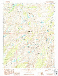
~ Tiltill Mountain CA topo map, 1:24000 scale, 7.5 X 7.5 Minute, Historical, 1990, updated 1990
Tiltill Mountain, California, USGS topographic map dated 1990.
Includes geographic coordinates (latitude and longitude). This topographic map is suitable for hiking, camping, and exploring, or framing it as a wall map.
Printed on-demand using high resolution imagery, on heavy weight and acid free paper, or alternatively on a variety of synthetic materials.
Topos available on paper, Waterproof, Poly, or Tyvek. Usually shipping rolled, unless combined with other folded maps in one order.
- Product Number: USGS-5524633
- Free digital map download (high-resolution, GeoPDF): Tiltill Mountain, California (file size: 13 MB)
- Map Size: please refer to the dimensions of the GeoPDF map above
- Weight (paper map): ca. 55 grams
- Map Type: POD USGS Topographic Map
- Map Series: HTMC
- Map Verison: Historical
- Cell ID: 45129
- Scan ID: 295465
- Imprint Year: 1990
- Woodland Tint: Yes
- Aerial Photo Year: 1984
- Edit Year: 1990
- Field Check Year: 1987
- Datum: NAD27
- Map Projection: Lambert Conformal Conic
- Map published by United States Geological Survey
- Map Language: English
- Scanner Resolution: 600 dpi
- Map Cell Name: Tiltill Mountain
- Grid size: 7.5 X 7.5 Minute
- Date on map: 1990
- Map Scale: 1:24000
- Geographical region: California, United States
Neighboring Maps:
All neighboring USGS topo maps are available for sale online at a variety of scales.
Spatial coverage:
Topo map Tiltill Mountain, California, covers the geographical area associated the following places:
- Moraine Ridge - Big Island Lake - Mahan Lake - Richardson Peak - Miwok Lake - Andrews Peak - Tilden Canyon Creek - Andrews Lake - Tiltill Mountain - Upper Branigan Lake - Tilden Canyon - Peninsula Lake - Upper Peninsula Lake - Fawn Lake - Lake Vernon - Haystack Peak - Bear Lake - Ardeth Lake - Wilma Lake - Jack Main Canyon - Olive Lake - Tilden Creek - Otter Lake - Edith Lake - Avonelle Lake - Bearup Lake - Little Otter Lake - Mahan Peak - Michie Peak - Wheeler Peak - Schofield Peak - Middle Branigan Lake - Branigan Lake - Kendrick Peak
- Map Area ID: AREA38.12538-119.75-119.625
- Northwest corner Lat/Long code: USGSNW38.125-119.75
- Northeast corner Lat/Long code: USGSNE38.125-119.625
- Southwest corner Lat/Long code: USGSSW38-119.75
- Southeast corner Lat/Long code: USGSSE38-119.625
- Northern map edge Latitude: 38.125
- Southern map edge Latitude: 38
- Western map edge Longitude: -119.75
- Eastern map edge Longitude: -119.625


