
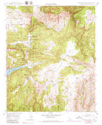
~ Rodriguez Mtn CA topo map, 1:24000 scale, 7.5 X 7.5 Minute, Historical, 1948, updated 1979
Rodriguez Mtn, California, USGS topographic map dated 1948.
Includes geographic coordinates (latitude and longitude). This topographic map is suitable for hiking, camping, and exploring, or framing it as a wall map.
Printed on-demand using high resolution imagery, on heavy weight and acid free paper, or alternatively on a variety of synthetic materials.
Topos available on paper, Waterproof, Poly, or Tyvek. Usually shipping rolled, unless combined with other folded maps in one order.
- Product Number: USGS-5521919
- Free digital map download (high-resolution, GeoPDF): Rodriguez Mtn, California (file size: 17 MB)
- Map Size: please refer to the dimensions of the GeoPDF map above
- Weight (paper map): ca. 55 grams
- Map Type: POD USGS Topographic Map
- Map Series: HTMC
- Map Verison: Historical
- Cell ID: 38426
- Scan ID: 294786
- Imprint Year: 1979
- Woodland Tint: Yes
- Photo Inspection Year: 1975
- Photo Revision Year: 1971
- Aerial Photo Year: 1975
- Field Check Year: 1948
- Datum: NAD27
- Map Projection: Polyconic
- Map published by United States Geological Survey
- Map Language: English
- Scanner Resolution: 600 dpi
- Map Cell Name: Rodriguez Mountain
- Grid size: 7.5 X 7.5 Minute
- Date on map: 1948
- Map Scale: 1:24000
- Geographical region: California, United States
Neighboring Maps:
All neighboring USGS topo maps are available for sale online at a variety of scales.
Spatial coverage:
Topo map Rodriguez Mtn, California, covers the geographical area associated the following places:
- Garlic Flats - French Mountain - Twin Flats - Paradise Mountain - Melrose Ranch - Escondido Canal - Bear Valley - Hell Creek - Valley Center Fire Protection District Station #2 - Hellhole Canyon County Open Space Preserve - San Pasqual Reservation Fire Academy - Armstrong Egg Farms - San Diego County Sheriff's Office Valley Center Substation - Lake Wohlford - Rodriguez Mountain - Cienaga Flats - Valley Center Division - Sycamore Flats - San Pasqual Reservation - Bear Spring Flats - Guejito - Bear Spring - Lower Hellhole - Upper Hellhole - Chimney Flats - Horsethief Canyon - Bear Valley School - Silvano Ranch - Vineyard Ranch - Fluegge Egg Ranch
- Map Area ID: AREA33.2533.125-117-116.875
- Northwest corner Lat/Long code: USGSNW33.25-117
- Northeast corner Lat/Long code: USGSNE33.25-116.875
- Southwest corner Lat/Long code: USGSSW33.125-117
- Southeast corner Lat/Long code: USGSSE33.125-116.875
- Northern map edge Latitude: 33.25
- Southern map edge Latitude: 33.125
- Western map edge Longitude: -117
- Eastern map edge Longitude: -116.875


