
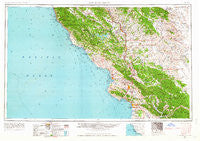
~ San Luis Obispo CA topo map, 1:250000 scale, 1 X 2 Degree, Historical, 1956, updated 1963
San Luis Obispo, California, USGS topographic map dated 1956.
Includes geographic coordinates (latitude and longitude). This topographic map is suitable for hiking, camping, and exploring, or framing it as a wall map.
Printed on-demand using high resolution imagery, on heavy weight and acid free paper, or alternatively on a variety of synthetic materials.
Topos available on paper, Waterproof, Poly, or Tyvek. Usually shipping rolled, unless combined with other folded maps in one order.
- Product Number: USGS-5506699
- Free digital map download (high-resolution, GeoPDF): San Luis Obispo, California (file size: 17 MB)
- Map Size: please refer to the dimensions of the GeoPDF map above
- Weight (paper map): ca. 55 grams
- Map Type: POD USGS Topographic Map
- Map Series: HTMC
- Map Verison: Historical
- Cell ID: 69015
- Scan ID: 302132
- Imprint Year: 1963
- Woodland Tint: Yes
- Edit Year: 1963
- Field Check Year: 1956
- Datum: Unstated
- Map Projection: Transverse Mercator
- Map published by United States Army Corps of Engineers
- Map published by United States Army
- Map Language: English
- Scanner Resolution: 600 dpi
- Map Cell Name: San Luis Obispo
- Grid size: 1 X 2 Degree
- Date on map: 1956
- Map Scale: 1:250000
- Geographical region: California, United States
Neighboring Maps:
All neighboring USGS topo maps are available for sale online at a variety of scales.
Spatial coverage:
Topo map San Luis Obispo, California, covers the geographical area associated the following places:
- San Lawrence Terrace - Eaglet (historical) - Bradley - Tin City - San Miguel - Thyle - Whitley Gardens - Packwood (historical) - San Luis Obispo - Cienega Seabreeze Mobile Home Park - Bromela - Gorda - Nipomo - Reef Station - Templeton - Pleyto (historical) - Morro Bay - Martinus Corner - Klau - Halcyon - Sycamore Springs - Harmony - Serrano - Los Osos - California Valley - Pozo - Garden Farms - Union - Hubert Place - East Village - Lake Nacimiento - Reeds (historical) - West Village - Steele (historical) - Avila Beach - Cholame - Estrella - Old Adobe - Huasna - Goldtree - Leimert - Cambria - Lodge Hill - Grover Beach - Miles - Oceano - Maxwellton (historical) - Wellsona - Happy Hill - Musick (historical) - Plaskett - Pleyto - Nacimiento - Annette - Summit (historical) - Cuna Vista Mobile Home Park - San Simeon - Acebedo - Asuncion - Fairoaks - Shell Beach - Los Berros - Cuesta-by-the-Sea - Oaks - Adelaida - Poloma (historical) - Cayucos - Navajo (historical) - Ken Mar Gardens Mobile Home Park - Lockwood - Paso Robles - Todd Place - Arroyo Grande - Edna - Linne - Creston - Santa Margarita - Henry - Bern - Wunpost - Shandon - Sans (historical) - Pismo Beach - Park Hill - Renshaw Place - Callender - Capital Hill - Atascadero - Martinez Place - Portico Mobile Home and Garden Park - Bryson - Marine Terrace - Sunset Palisades - Hathaway Place - Oak Park - Cushing - Reeves Place - Wilson Corner - Summers (historical) - Newsom Springs
- Map Area ID: AREA3635-122-120
- Northwest corner Lat/Long code: USGSNW36-122
- Northeast corner Lat/Long code: USGSNE36-120
- Southwest corner Lat/Long code: USGSSW35-122
- Southeast corner Lat/Long code: USGSSE35-120
- Northern map edge Latitude: 36
- Southern map edge Latitude: 35
- Western map edge Longitude: -122
- Eastern map edge Longitude: -120


