
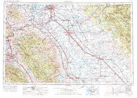
~ San Jose CA topo map, 1:250000 scale, 1 X 2 Degree, Historical, 1962, updated 1977
San Jose, California, USGS topographic map dated 1962.
Includes geographic coordinates (latitude and longitude). This topographic map is suitable for hiking, camping, and exploring, or framing it as a wall map.
Printed on-demand using high resolution imagery, on heavy weight and acid free paper, or alternatively on a variety of synthetic materials.
Topos available on paper, Waterproof, Poly, or Tyvek. Usually shipping rolled, unless combined with other folded maps in one order.
- Product Number: USGS-5506689
- Free digital map download (high-resolution, GeoPDF): San Jose, California (file size: 22 MB)
- Map Size: please refer to the dimensions of the GeoPDF map above
- Weight (paper map): ca. 55 grams
- Map Type: POD USGS Topographic Map
- Map Series: HTMC
- Map Verison: Historical
- Cell ID: 74989
- Scan ID: 302127
- Imprint Year: 1977
- Woodland Tint: Yes
- Aerial Photo Year: 1960
- Edit Year: 1969
- Field Check Year: 1962
- Datum: Unstated
- Map Projection: Transverse Mercator
- Map published by United States Geological Survey
- Map published by: Military, Other
- Map Language: English
- Scanner Resolution: 600 dpi
- Map Cell Name: San Jose
- Grid size: 1 X 2 Degree
- Date on map: 1962
- Map Scale: 1:250000
- Geographical region: California, United States
Neighboring Maps:
All neighboring USGS topo maps are available for sale online at a variety of scales.
Spatial coverage:
Topo map San Jose, California, covers the geographical area associated the following places:
- Dairyland - Notarb - North McHenry - Rock City - Delhi - Berenda - Edendale (historical) - Diablo Grande - Trevarno - Blackslough Landing - East Oakdale - Jet - Yarmouth (historical) - Elliot (historical) - Tuttletown - Santa Nella Village - Willow Springs - Huntley - Athlone - Danville - Scotts Corner - Ashrama - Lonoke - Centerville District - Quail Hollow - Jamestown - Guadalupe (historical) - Kennedy - Ralph - Scenic View - Madera Country Club Estates - Cuba (historical) - Asco - Cooperstown - Turner - Vasona Junction - Johnsville Mobile Home Park - Farmington - Byron - Drawbridge (historical) - Empire - Gustine - South Coyote - Atlanta - Atwater - Colfax Spring - Arastraville - Hilmar - Monte Grande Heights - Castle Gardens - Big Oak Flat - Mono Vista - Blanchard - Casa Amigo Mobile Home Park - Coyote - Yosemite Junction - San Jose Mobile Home Park - Larson - Rancho Poquitos - Keystone - Sunshine Camp - Tassajara - Moccasin - Mountain Home - The Willows - Lexington Hills - Montezuma - Agnew - Riverbank - Campbell - Plains (historical) - Standiford - Arena - McHenry - Vanormer (historical) - Burchell (historical) - Tuolumne - Oakdale - Escalon - Wagner - Fluhr - Valley Home - Sunol - Heavenly Hills - Eugene - Bridgeport - Niles District - Aurora - Tuolumne City (historical) - Robertsville - Ellis (historical) - Parkmoor - Santa Clara - Meyers (historical) - Lyoth - Mission San Jose District - Alviso - Diamond Bar B Ranch - Sibley (historical) - Magnetic Spring (historical)
- Map Area ID: AREA3837-122-120
- Northwest corner Lat/Long code: USGSNW38-122
- Northeast corner Lat/Long code: USGSNE38-120
- Southwest corner Lat/Long code: USGSSW37-122
- Southeast corner Lat/Long code: USGSSE37-120
- Northern map edge Latitude: 38
- Southern map edge Latitude: 37
- Western map edge Longitude: -122
- Eastern map edge Longitude: -120


