
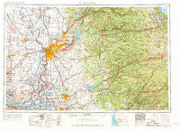
~ Sacramento CA topo map, 1:250000 scale, 1 X 2 Degree, Historical, 1957, updated 1969
Sacramento, California, USGS topographic map dated 1957.
Includes geographic coordinates (latitude and longitude). This topographic map is suitable for hiking, camping, and exploring, or framing it as a wall map.
Printed on-demand using high resolution imagery, on heavy weight and acid free paper, or alternatively on a variety of synthetic materials.
Topos available on paper, Waterproof, Poly, or Tyvek. Usually shipping rolled, unless combined with other folded maps in one order.
- Product Number: USGS-5506619
- Free digital map download (high-resolution, GeoPDF): Sacramento, California (file size: 22 MB)
- Map Size: please refer to the dimensions of the GeoPDF map above
- Weight (paper map): ca. 55 grams
- Map Type: POD USGS Topographic Map
- Map Series: HTMC
- Map Verison: Historical
- Cell ID: 68999
- Scan ID: 299858
- Imprint Year: 1969
- Woodland Tint: Yes
- Edit Year: 1964
- Field Check Year: 1957
- Datum: Unstated
- Map Projection: Transverse Mercator
- Map published by United States Army Corps of Engineers
- Map Language: English
- Scanner Resolution: 600 dpi
- Map Cell Name: Sacramento
- Grid size: 1 X 2 Degree
- Date on map: 1957
- Map Scale: 1:250000
- Geographical region: California, United States
Neighboring Maps:
All neighboring USGS topo maps are available for sale online at a variety of scales.
Spatial coverage:
Topo map Sacramento, California, covers the geographical area associated the following places:
- Perkins - Morada - Yolo - Belleview - Balderson Station - Edwin - Mokelumne City - Camanche Village - Loomis - Oak Grove - Golden Chain Mobile Home Park - Morgans Landing - Yolano - Cunard - Green Springs Ranch - Milligan District (historical) - Soudan - Antioch - Cranmore - Hidden Valley - Walerga - Deer Park - Sutter Hill - Dagon - Norton - El Dorado Hills - Del Paso Heights - Soapweed - Pope - Tomspur - Arroyo Vista - High Sierra Park - Eagle Tree - Arcade - Herald - Garden Acres Mobile Home Park - Taison (historical) - Lincoln - Volcano - Montezuma - Kiva Beach - La Riviera - Citrus - Counsman - Bay Point - Phoenix Lake County Club Estates - Coniston - Parkway - Placerville - El Rancho Mobile Park - El Rio Villa - Pearson - Pilot Hill - Tyndall Landing - Walnut Trailer Villa - Lilac Terrace - Cameron Airpark Estates - Marble Mountain - Green - San Andreas - Ensley - Joes Landing - Ryde - Wallace - Madison - Felix - Ranch House Estates - Malby Crossing - Griminger - Franciscan Village - Lake Hills Estates - Cicero (historical) - Fairbanks - Centralia - Kit Carson - Leeman (historical) - Ambrose (historical) - Bridgehead - Blue Lake Springs - Carmichael - Hathaways Mountain Pines - Vallecito - Urgon - Pacific - Green Valley Acres - Ramona - Swingle - Hebron (historical) - Webster - Pittsburg - Snowshoe Springs - Linden - Phoenix Lake - Pilliken - Echo Lake - Royal Oak Manufactured Home Community - Ophir - Tamarack Springs - Wilton - Ione
- Map Area ID: AREA3938-122-120
- Northwest corner Lat/Long code: USGSNW39-122
- Northeast corner Lat/Long code: USGSNE39-120
- Southwest corner Lat/Long code: USGSSW38-122
- Southeast corner Lat/Long code: USGSSE38-120
- Northern map edge Latitude: 39
- Southern map edge Latitude: 38
- Western map edge Longitude: -122
- Eastern map edge Longitude: -120


