
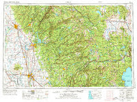
~ Chico CA topo map, 1:250000 scale, 1 X 2 Degree, Historical, 1958, updated 1974
Chico, California, USGS topographic map dated 1958.
Includes geographic coordinates (latitude and longitude). This topographic map is suitable for hiking, camping, and exploring, or framing it as a wall map.
Printed on-demand using high resolution imagery, on heavy weight and acid free paper, or alternatively on a variety of synthetic materials.
Topos available on paper, Waterproof, Poly, or Tyvek. Usually shipping rolled, unless combined with other folded maps in one order.
- Product Number: USGS-5506515
- Free digital map download (high-resolution, GeoPDF): Chico, California (file size: 25 MB)
- Map Size: please refer to the dimensions of the GeoPDF map above
- Weight (paper map): ca. 55 grams
- Map Type: POD USGS Topographic Map
- Map Series: HTMC
- Map Verison: Historical
- Cell ID: 72222
- Scan ID: 299748
- Imprint Year: 1974
- Woodland Tint: Yes
- Aerial Photo Year: 1969
- Edit Year: 1970
- Field Check Year: 1958
- Datum: Unstated
- Map Projection: Transverse Mercator
- Map published by: Military, Other
- Map Language: English
- Scanner Resolution: 600 dpi
- Map Cell Name: Chico
- Grid size: 1 X 2 Degree
- Date on map: 1958
- Map Scale: 1:250000
- Geographical region: California, United States
Neighboring Maps:
All neighboring USGS topo maps are available for sale online at a variety of scales.
Spatial coverage:
Topo map Chico, California, covers the geographical area associated the following places:
- Nelson Bar (historical) - Cisco - Encinal - Alta Vista Park - Stanfield Hill - Linda - Oroville Junction - Pomins - Centerville (historical) - Inskip - Fraziers Landing - Mooney Flat - Palermo - Whitehawk - Argentine (historical) - West Linda - Colfax - Blinzing (historical) - Cherokee - Snow Point (historical) - Tamarack (historical) - Carnelian Heights - Robinsons Corner - Ridge View - Merlin - Butte City - Yuba Mobile Home Park - Rampart - Badger Hill (historical) - Dobbins - Weeks Tract - Snow Tent (historical) - Bath (historical) - Arbee - Bitney Corner - Pulga - Junction House - Haskell Creek Homesites - Meadow Valley - Colusa Junction - Ridgewood - Richardson Springs - Olympia Glade - Mayaro - Pinecrest - Union Mills - Pipers (historical) - Mohawk - Hirschdale - Butte House (historical) - Biggs - Bridgeport - Birch Meadow Acres - Meadow Vista - Lake Wildwood - Jacobsen (historical) - Oxford Mill - Poker Flat - Cypress Hill - Brockway Vista - Magalia - Strawberry Valley - Newtown - Alicia - Cherokee - Kings Beach - Gateway - Tahoe Woods - Casey Corner - Castlewood Mobile Home Park - Merrimac - Baltimore (historical) - Minnesota Flat - Moseley (historical) - Rodgers Flat - Yuba Pass - Rainbow - Spring Hill - Iron Horse - Lorraine (historical) - Timberland - Chapmantown - Chico - Echo Ridge Trails - Starbright Acres - Maredith Mill - Dean Place - Sunnyslope - Lira - Durham - Tambo - Thermalito - Pearson - Sanders - Highland Park - Concow - Oregon City - Howland Flat - Ponderosa Palisades - Sutter
- Map Area ID: AREA4039-122-120
- Northwest corner Lat/Long code: USGSNW40-122
- Northeast corner Lat/Long code: USGSNE40-120
- Southwest corner Lat/Long code: USGSSW39-122
- Southeast corner Lat/Long code: USGSSE39-120
- Northern map edge Latitude: 40
- Southern map edge Latitude: 39
- Western map edge Longitude: -122
- Eastern map edge Longitude: -120


