
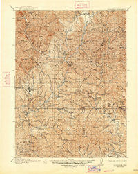
~ Weaverville CA topo map, 1:125000 scale, 30 X 30 Minute, Historical, 1913, updated 1947
Weaverville, California, USGS topographic map dated 1913.
Includes geographic coordinates (latitude and longitude). This topographic map is suitable for hiking, camping, and exploring, or framing it as a wall map.
Printed on-demand using high resolution imagery, on heavy weight and acid free paper, or alternatively on a variety of synthetic materials.
Topos available on paper, Waterproof, Poly, or Tyvek. Usually shipping rolled, unless combined with other folded maps in one order.
- Product Number: USGS-5506435
- Free digital map download (high-resolution, GeoPDF): Weaverville, California (file size: 14 MB)
- Map Size: please refer to the dimensions of the GeoPDF map above
- Weight (paper map): ca. 55 grams
- Map Type: POD USGS Topographic Map
- Map Series: HTMC
- Map Verison: Historical
- Cell ID: 66906
- Scan ID: 302097
- Imprint Year: 1947
- Survey Year: 1911
- Datum: NAD
- Map Projection: Polyconic
- Map published by United States Geological Survey
- Map Language: English
- Scanner Resolution: 600 dpi
- Map Cell Name: Weaverville
- Grid size: 30 X 30 Minute
- Date on map: 1913
- Map Scale: 1:125000
- Geographical region: California, United States
Neighboring Maps:
All neighboring USGS topo maps are available for sale online at a variety of scales.
Spatial coverage:
Topo map Weaverville, California, covers the geographical area associated the following places:
- Pinewood Cove - Lewiston - Bragdon (historical) - Deadwood - Douglas City - Ridgeville - Weaverville - Bucktail - Keno (historical) - Paige Bar - Igo - Fairview - Cedar Stock - French Gulch - Trinity Center - Minersville (historical) - Iron Mountain - Oak Bottom (historical) - Trinity Alps - Whiskeytown - Estrellita
- Map Area ID: AREA4140.5-123-122.5
- Northwest corner Lat/Long code: USGSNW41-123
- Northeast corner Lat/Long code: USGSNE41-122.5
- Southwest corner Lat/Long code: USGSSW40.5-123
- Southeast corner Lat/Long code: USGSSE40.5-122.5
- Northern map edge Latitude: 41
- Southern map edge Latitude: 40.5
- Western map edge Longitude: -123
- Eastern map edge Longitude: -122.5


