
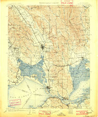
~ Napa CA topo map, 1:125000 scale, 30 X 30 Minute, Historical, 1902, updated 1902
Napa, California, USGS topographic map dated 1902.
Includes geographic coordinates (latitude and longitude). This topographic map is suitable for hiking, camping, and exploring, or framing it as a wall map.
Printed on-demand using high resolution imagery, on heavy weight and acid free paper, or alternatively on a variety of synthetic materials.
Topos available on paper, Waterproof, Poly, or Tyvek. Usually shipping rolled, unless combined with other folded maps in one order.
- Product Number: USGS-5506083
- Free digital map download (high-resolution, GeoPDF): Napa, California (file size: 11 MB)
- Map Size: please refer to the dimensions of the GeoPDF map above
- Weight (paper map): ca. 55 grams
- Map Type: POD USGS Topographic Map
- Map Series: HTMC
- Map Verison: Historical
- Cell ID: 66156
- Scan ID: 299520
- Imprint Year: 1902
- Survey Year: 1899
- Datum: Unstated
- Map Projection: Unstated
- Map published by United States Geological Survey
- Map Language: English
- Scanner Resolution: 600 dpi
- Map Cell Name: Napa
- Grid size: 30 X 30 Minute
- Date on map: 1902
- Map Scale: 1:125000
- Geographical region: California, United States
Neighboring Maps:
All neighboring USGS topo maps are available for sale online at a variety of scales.
Spatial coverage:
Topo map Napa, California, covers the geographical area associated the following places:
- Clyde - Tormey - Cygnus - Lombard - Napa Junction - Oleum - Danielson - Subeet - Park Creek Village Mobile Home Park - Vine Hill - Bayo Vista - Martinez - Herpoco - Vineburg - Ohmer (historical) - Salvador - Harry Floyd Terrace - Fairville - Greenwood (historical) - Rose (historical) - Flosden (historical) - Napa Soda Springs - Teal - Ozol - Embarcadero - Monsanto - Zinfandel - McGill - Suscol - Valona - Rodeo - Ratto Landing - Lokoya - Collins - Mountain View - Mankas Corner - Thompson - Middleton - Luzon - Union - Oakville - Shellville Colony - Cordelia Junction - Four Corners - Imola - Lowell - El Verano - Atlas - Enchanted Hills - Avon - Yountville - Squab - Mococo - Shipyard Acres - Pueblo Serena Mobile Home Park - Carneros (historical) - Rockville - Caymus (historical) - South Vallejo - Oak Knoll - Pinole - Temelec - Bucktown - Pierce - Buena Vista - Cuttings Wharf - Buchli - Vichy Springs - Rancho Ramon Mobile Home Park - Rutherford - Guadalcanal Village - Napa - Thoman - Fairfield - Boyes Hot Springs - Chabot Terrace - Stanley - Agua Caliente - Batto - Sobrante - Gateley - Russell - Crolona Heights - Benicia - Bayview - Port Costa - Port Chicago (historical) - Glencove - Rocktram - Jacksnipe - De Anza Moon Valley Mobile Home Park - Suisun - Sonoma - Christie - Vallejo - Bahia - Nitro - Sears Point - Big Bend - Rancho Vista Mobile Home Park
- Map Area ID: AREA38.538-122.5-122
- Northwest corner Lat/Long code: USGSNW38.5-122.5
- Northeast corner Lat/Long code: USGSNE38.5-122
- Southwest corner Lat/Long code: USGSSW38-122.5
- Southeast corner Lat/Long code: USGSSE38-122
- Northern map edge Latitude: 38.5
- Southern map edge Latitude: 38
- Western map edge Longitude: -122.5
- Eastern map edge Longitude: -122


