
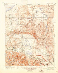
~ Mt Morrison CA topo map, 1:125000 scale, 30 X 30 Minute, Historical, 1914, updated 1945
Mt Morrison, California, USGS topographic map dated 1914.
Includes geographic coordinates (latitude and longitude). This topographic map is suitable for hiking, camping, and exploring, or framing it as a wall map.
Printed on-demand using high resolution imagery, on heavy weight and acid free paper, or alternatively on a variety of synthetic materials.
Topos available on paper, Waterproof, Poly, or Tyvek. Usually shipping rolled, unless combined with other folded maps in one order.
- Product Number: USGS-5506037
- Free digital map download (high-resolution, GeoPDF): Mt Morrison, California (file size: 9 MB)
- Map Size: please refer to the dimensions of the GeoPDF map above
- Weight (paper map): ca. 55 grams
- Map Type: POD USGS Topographic Map
- Map Series: HTMC
- Map Verison: Historical
- Cell ID: 66124
- Scan ID: 299496
- Imprint Year: 1945
- Survey Year: 1912
- Datum: NAD
- Map Projection: Polyconic
- Map published by United States Geological Survey
- Map Language: English
- Scanner Resolution: 600 dpi
- Map Cell Name: Mount Morrison
- Grid size: 30 X 30 Minute
- Date on map: 1914
- Map Scale: 1:125000
- Geographical region: California, United States
Neighboring Maps:
All neighboring USGS topo maps are available for sale online at a variety of scales.
Spatial coverage:
Topo map Mt Morrison, California, covers the geographical area associated the following places:
- North Landing - Whitmore Hot Springs - Toms Place - Mill City (historical) - Pizona - Crestview - Benton Crossing - Mono Mills - Mammoth Lakes - Old Mammoth - South Landing - Aspen Springs - Mesa Camp - Benton Hot Springs
- Map Area ID: AREA3837.5-119-118.5
- Northwest corner Lat/Long code: USGSNW38-119
- Northeast corner Lat/Long code: USGSNE38-118.5
- Southwest corner Lat/Long code: USGSSW37.5-119
- Southeast corner Lat/Long code: USGSSE37.5-118.5
- Northern map edge Latitude: 38
- Southern map edge Latitude: 37.5
- Western map edge Longitude: -119
- Eastern map edge Longitude: -118.5


