
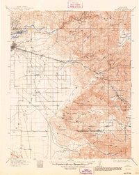
~ Caliente CA topo map, 1:125000 scale, 30 X 30 Minute, Historical, 1914, updated 1948
Caliente, California, USGS topographic map dated 1914.
Includes geographic coordinates (latitude and longitude). This topographic map is suitable for hiking, camping, and exploring, or framing it as a wall map.
Printed on-demand using high resolution imagery, on heavy weight and acid free paper, or alternatively on a variety of synthetic materials.
Topos available on paper, Waterproof, Poly, or Tyvek. Usually shipping rolled, unless combined with other folded maps in one order.
- Product Number: USGS-5505625
- Free digital map download (high-resolution, GeoPDF): Caliente, California (file size: 9 MB)
- Map Size: please refer to the dimensions of the GeoPDF map above
- Weight (paper map): ca. 55 grams
- Map Type: POD USGS Topographic Map
- Map Series: HTMC
- Map Verison: Historical
- Cell ID: 65101
- Scan ID: 299255
- Imprint Year: 1948
- Survey Year: 1912
- Datum: NAD
- Map Projection: Polyconic
- Map published by United States Geological Survey
- Map Language: English
- Scanner Resolution: 600 dpi
- Map Cell Name: Caliente
- Grid size: 30 X 30 Minute
- Date on map: 1914
- Map Scale: 1:125000
- Geographical region: California, United States
Neighboring Maps:
All neighboring USGS topo maps are available for sale online at a variety of scales.
Spatial coverage:
Topo map Caliente, California, covers the geographical area associated the following places:
- Lamont - El Rita - Harpertown - Rock Springs (historical) - Arvin - Stallion Springs - Rowen - Mettler - Algoso - Ilmon - Lonsmith - Caliente - Oil City - Treves (historical) - Woodford - Vaccaro (historical) - Magunden - Walong - Bena - Keene - Weedpatch - Five Points - Maltha - Kern - Ribier - Wheeler Ridge - Meridian - East Bakersfield - Fuller Acres - Marcel - Fig Orchard - Edison - Bealville - Arvin Mobile Home Estates - Mitchells Corner - Bear Valley Springs - Patch - Kayandee - Mayfair - Edmundson Acres - Di Giorgio
- Map Area ID: AREA35.535-119-118.5
- Northwest corner Lat/Long code: USGSNW35.5-119
- Northeast corner Lat/Long code: USGSNE35.5-118.5
- Southwest corner Lat/Long code: USGSSW35-119
- Southeast corner Lat/Long code: USGSSE35-118.5
- Northern map edge Latitude: 35.5
- Southern map edge Latitude: 35
- Western map edge Longitude: -119
- Eastern map edge Longitude: -118.5


