
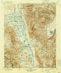
~ Bishop CA topo map, 1:125000 scale, 30 X 30 Minute, Historical, 1913, updated 1941
Bishop, California, USGS topographic map dated 1913.
Includes geographic coordinates (latitude and longitude). This topographic map is suitable for hiking, camping, and exploring, or framing it as a wall map.
Printed on-demand using high resolution imagery, on heavy weight and acid free paper, or alternatively on a variety of synthetic materials.
Topos available on paper, Waterproof, Poly, or Tyvek. Usually shipping rolled, unless combined with other folded maps in one order.
- Product Number: USGS-5505579
- Free digital map download (high-resolution, GeoPDF): Bishop, California (file size: 11 MB)
- Map Size: please refer to the dimensions of the GeoPDF map above
- Weight (paper map): ca. 55 grams
- Map Type: POD USGS Topographic Map
- Map Series: HTMC
- Map Verison: Historical
- Cell ID: 65007
- Scan ID: 299232
- Imprint Year: 1941
- Survey Year: 1911
- Datum: NAD
- Map Projection: Polyconic
- Map published by United States Geological Survey
- Map Language: English
- Scanner Resolution: 600 dpi
- Map Cell Name: Bishop
- Grid size: 30 X 30 Minute
- Date on map: 1913
- Map Scale: 1:125000
- Geographical region: California, United States
Neighboring Maps:
All neighboring USGS topo maps are available for sale online at a variety of scales.
Spatial coverage:
Topo map Bishop, California, covers the geographical area associated the following places:
- Glenwood Mobile Estates - Fish Springs - Zurich - Big Pine - Sunrise Mobile Home Park - West Bishop - Bishop Trail Park - Highlands Mobile Home Park - Shady Rest Trailer and Recreational Vehicle Park - Monola - Brockmans Corner - Bishop - Rocking K - Keough Hot Springs - Genes Mobile Home Park - Peterson Mill - Sunland (historical) - Poleta - Laws - Mountain View Mobile and Recreational Vehicle Park - J Diamond Trailer and Recreational Vehicle Park - Sierra Trailer Park - Elna (historical) - Meadow Farms Trailer Park - Oteys Sierra Village
- Map Area ID: AREA37.537-118.5-118
- Northwest corner Lat/Long code: USGSNW37.5-118.5
- Northeast corner Lat/Long code: USGSNE37.5-118
- Southwest corner Lat/Long code: USGSSW37-118.5
- Southeast corner Lat/Long code: USGSSE37-118
- Northern map edge Latitude: 37.5
- Southern map edge Latitude: 37
- Western map edge Longitude: -118.5
- Eastern map edge Longitude: -118


