
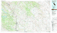
~ Paso Robles CA topo map, 1:100000 scale, 30 X 60 Minute, Historical, 1989, updated 1989
Paso Robles, California, USGS topographic map dated 1989.
Includes geographic coordinates (latitude and longitude). This topographic map is suitable for hiking, camping, and exploring, or framing it as a wall map.
Printed on-demand using high resolution imagery, on heavy weight and acid free paper, or alternatively on a variety of synthetic materials.
Topos available on paper, Waterproof, Poly, or Tyvek. Usually shipping rolled, unless combined with other folded maps in one order.
- Product Number: USGS-5505373
- Free digital map download (high-resolution, GeoPDF): Paso Robles, California (file size: 27 MB)
- Map Size: please refer to the dimensions of the GeoPDF map above
- Weight (paper map): ca. 55 grams
- Map Type: POD USGS Topographic Map
- Map Series: HTMC
- Map Verison: Historical
- Cell ID: 68127
- Scan ID: 299140
- Imprint Year: 1989
- Woodland Tint: Yes
- Aerial Photo Year: 1987
- Edit Year: 1989
- Datum: NAD27
- Map Projection: Universal Transverse Mercator
- Map published by United States Geological Survey
- Map Language: English
- Scanner Resolution: 600 dpi
- Map Cell Name: Paso Robles
- Grid size: 30 X 60 Minute
- Date on map: 1989
- Map Scale: 1:100000
- Geographical region: California, United States
Neighboring Maps:
All neighboring USGS topo maps are available for sale online at a variety of scales.
Spatial coverage:
Topo map Paso Robles, California, covers the geographical area associated the following places:
- Summers (historical) - Estrella - Reef Station - Whitley Gardens - San Lawrence Terrace - Pleyto (historical) - Bradley - Templeton - Shandon - Adelaida - Wellsona - Nacimiento - Parkfield - Creston - Cholame - McKay - San Miguel - Lake Nacimiento - Asuncion - Klau - Paso Robles - Linne - Oak Park - Old Adobe - Capital Hill - Annette - Bee Rock - Packwood (historical) - Wunpost - Kecks Corner - Bern - Pleyto - Valleton - Union - Acebedo
- Map Area ID: AREA3635.5-121-120
- Northwest corner Lat/Long code: USGSNW36-121
- Northeast corner Lat/Long code: USGSNE36-120
- Southwest corner Lat/Long code: USGSSW35.5-121
- Southeast corner Lat/Long code: USGSSE35.5-120
- Northern map edge Latitude: 36
- Southern map edge Latitude: 35.5
- Western map edge Longitude: -121
- Eastern map edge Longitude: -120


