
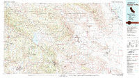
~ Borrego Valley CA topo map, 1:100000 scale, 30 X 60 Minute, Historical, 1982, updated 1983
Borrego Valley, California, USGS topographic map dated 1982.
Includes geographic coordinates (latitude and longitude). This topographic map is suitable for hiking, camping, and exploring, or framing it as a wall map.
Printed on-demand using high resolution imagery, on heavy weight and acid free paper, or alternatively on a variety of synthetic materials.
Topos available on paper, Waterproof, Poly, or Tyvek. Usually shipping rolled, unless combined with other folded maps in one order.
- Product Number: USGS-5505221
- Free digital map download (high-resolution, GeoPDF): Borrego Valley, California (file size: 29 MB)
- Map Size: please refer to the dimensions of the GeoPDF map above
- Weight (paper map): ca. 55 grams
- Map Type: POD USGS Topographic Map
- Map Series: HTMC
- Map Verison: Historical
- Cell ID: 67171
- Scan ID: 299054
- Imprint Year: 1983
- Woodland Tint: Yes
- Visual Version Number: 2
- Aerial Photo Year: 1977
- Edit Year: 1982
- Datum: NAD27
- Map Projection: Universal Transverse Mercator
- Map published by United States Geological Survey
- Map Language: English
- Scanner Resolution: 600 dpi
- Map Cell Name: Borrego Valley
- Grid size: 30 X 60 Minute
- Date on map: 1982
- Map Scale: 1:100000
- Geographical region: California, United States
Neighboring Maps:
All neighboring USGS topo maps are available for sale online at a variety of scales.
Spatial coverage:
Topo map Borrego Valley, California, covers the geographical area associated the following places:
- La Jolla Amago - Banner - Branson (historical) - Scissors Crossing - Harrison Park - San Ysidro - Santa Ysabel - Butterfield Lake Estates - Eagles Nest - Radec - Pine Hills - Warner Springs - Mesa Grande - San Pasqual - San Felipe - Holcomb Village - Morettis Junction - Ballena - Silver Dons Mobile Home Park - Borrego Springs - Ramona - Rincon - Rosemont - Desert Shores - Borrego - Oasis - Desert Lodge - Holiday Home Mobile Home Park - Los Tules - Desert Sands Mobile Home Park - Julian - San Ignacio - Aguanga - Whispering Pines - Kentwood-In-The-Pines - Ranchita - Oak Grove - Pauma Valley - Salton Sea Beach - San Diego Country Estates - Wynola - Hellhole Palms - Ocotillo Wells - El Rancho Mobile Home Park - Coolidge Springs - Palomar Mountain
- Map Area ID: AREA33.533-117-116
- Northwest corner Lat/Long code: USGSNW33.5-117
- Northeast corner Lat/Long code: USGSNE33.5-116
- Southwest corner Lat/Long code: USGSSW33-117
- Southeast corner Lat/Long code: USGSSE33-116
- Northern map edge Latitude: 33.5
- Southern map edge Latitude: 33
- Western map edge Longitude: -117
- Eastern map edge Longitude: -116


