
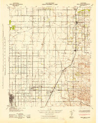
~ Terra Bella CA topo map, 1:62500 scale, 15 X 15 Minute, Historical, 1942, updated 1942
Terra Bella, California, USGS topographic map dated 1942.
Includes geographic coordinates (latitude and longitude). This topographic map is suitable for hiking, camping, and exploring, or framing it as a wall map.
Printed on-demand using high resolution imagery, on heavy weight and acid free paper, or alternatively on a variety of synthetic materials.
Topos available on paper, Waterproof, Poly, or Tyvek. Usually shipping rolled, unless combined with other folded maps in one order.
- Product Number: USGS-5504757
- Free digital map download (high-resolution, GeoPDF): Terra Bella, California (file size: 6 MB)
- Map Size: please refer to the dimensions of the GeoPDF map above
- Weight (paper map): ca. 55 grams
- Map Type: POD USGS Topographic Map
- Map Series: HTMC
- Map Verison: Historical
- Cell ID: 63459
- Scan ID: 301816
- Imprint Year: 1942
- Woodland Tint: Yes
- Aerial Photo Year: 1937
- Survey Year: 1926
- Datum: NAD27
- Map Projection: Polyconic
- Map published by United States Army Corps of Engineers
- Map published by United States Department of War
- Map Language: English
- Scanner Resolution: 600 dpi
- Map Cell Name: Terra Bella
- Grid size: 15 X 15 Minute
- Date on map: 1942
- Map Scale: 1:62500
- Geographical region: California, United States
Neighboring Maps:
All neighboring USGS topo maps are available for sale online at a variety of scales.
Spatial coverage:
Topo map Terra Bella, California, covers the geographical area associated the following places:
- Delano Mobile Home Park - Quality - Ducor - Delano - Deer Creek Colony - Richgrove - Saucelito - Elmco - Trocha - Orris - Terra Bella - Cypress Gardens Mobile Home Community - Jovista - Vestal
- Map Area ID: AREA3635.75-119.25-119
- Northwest corner Lat/Long code: USGSNW36-119.25
- Northeast corner Lat/Long code: USGSNE36-119
- Southwest corner Lat/Long code: USGSSW35.75-119.25
- Southeast corner Lat/Long code: USGSSE35.75-119
- Northern map edge Latitude: 36
- Southern map edge Latitude: 35.75
- Western map edge Longitude: -119.25
- Eastern map edge Longitude: -119


