
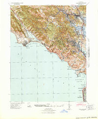
~ Tamalpais CA topo map, 1:62500 scale, 15 X 15 Minute, Historical, 1941
Tamalpais, California, USGS topographic map dated 1941.
Includes geographic coordinates (latitude and longitude). This topographic map is suitable for hiking, camping, and exploring, or framing it as a wall map.
Printed on-demand using high resolution imagery, on heavy weight and acid free paper, or alternatively on a variety of synthetic materials.
Topos available on paper, Waterproof, Poly, or Tyvek. Usually shipping rolled, unless combined with other folded maps in one order.
- Product Number: USGS-5504703
- Free digital map download (high-resolution, GeoPDF): Tamalpais, California (file size: 10 MB)
- Map Size: please refer to the dimensions of the GeoPDF map above
- Weight (paper map): ca. 55 grams
- Map Type: POD USGS Topographic Map
- Map Series: HTMC
- Map Verison: Historical
- Cell ID: 58128
- Scan ID: 301788
- Woodland Tint: Yes
- Aerial Photo Year: 1939
- Datum: NAD27
- Map Projection: Polyconic
- Map published by United States Army Corps of Engineers
- Map Language: English
- Scanner Resolution: 600 dpi
- Map Cell Name: Mount Tamalapais
- Grid size: 15 X 15 Minute
- Date on map: 1941
- Map Scale: 1:62500
- Geographical region: California, United States
Neighboring Maps:
All neighboring USGS topo maps are available for sale online at a variety of scales.
Spatial coverage:
Topo map Tamalpais, California, covers the geographical area associated the following places:
- Larkspur - Corte Madera - Almonte - Bolinas - Manor - Escalle - Los Ranchitos - Woodville - Chapman - Waldo - Meadowsweet - Homestead Valley - Manzanita - Reed - San Rafael - Marin City - Muir Beach - Murray Park - Tamalpais Valley - Tamalpais Valley Junction - Stinson Beach - Cerro - Santa Venetia - Kent Woodlands - Baltimore Park - Ross - Alto - Strawberry - Strawberry Manor - San Anselmo - Harbor Point - Mill Valley - Fairfax - Greenbrae - Kentfield
- Map Area ID: AREA3837.75-122.75-122.5
- Northwest corner Lat/Long code: USGSNW38-122.75
- Northeast corner Lat/Long code: USGSNE38-122.5
- Southwest corner Lat/Long code: USGSSW37.75-122.75
- Southeast corner Lat/Long code: USGSSE37.75-122.5
- Northern map edge Latitude: 38
- Southern map edge Latitude: 37.75
- Western map edge Longitude: -122.75
- Eastern map edge Longitude: -122.5


