
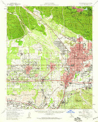
~ San Bernardino CA topo map, 1:62500 scale, 15 X 15 Minute, Historical, 1954, updated 1959
San Bernardino, California, USGS topographic map dated 1954.
Includes geographic coordinates (latitude and longitude). This topographic map is suitable for hiking, camping, and exploring, or framing it as a wall map.
Printed on-demand using high resolution imagery, on heavy weight and acid free paper, or alternatively on a variety of synthetic materials.
Topos available on paper, Waterproof, Poly, or Tyvek. Usually shipping rolled, unless combined with other folded maps in one order.
- Product Number: USGS-5504173
- Free digital map download (high-resolution, GeoPDF): San Bernardino, California (file size: 10 MB)
- Map Size: please refer to the dimensions of the GeoPDF map above
- Weight (paper map): ca. 55 grams
- Map Type: POD USGS Topographic Map
- Map Series: HTMC
- Map Verison: Historical
- Cell ID: 62067
- Scan ID: 298872
- Imprint Year: 1959
- Woodland Tint: Yes
- Aerial Photo Year: 1952
- Survey Year: 1954
- Datum: NAD27
- Map Projection: Polyconic
- Map published by United States Geological Survey
- Map Language: English
- Scanner Resolution: 600 dpi
- Map Cell Name: San Bernardino
- Grid size: 15 X 15 Minute
- Date on map: 1954
- Map Scale: 1:62500
- Geographical region: California, United States
Neighboring Maps:
All neighboring USGS topo maps are available for sale online at a variety of scales.
Spatial coverage:
Topo map San Bernardino, California, covers the geographical area associated the following places:
- Crestmore - Walnut Ridge - Ailsa (historical) - University Heights - Arrowhead Farms - North Loma Linda - Victoria - Kaiser - Valencia - Devil Canyon - East Colton Heights - Bunker Hill - Arrowhead Springs - Colton - Highgrove - Rana - Crestline - Glen Avon - Serrano Village - Declezville - West Colton - San Bernardino - Ormand - Valley View Park - Bethune - Valley of Enchantment - Muscoy - Belltown - Devore - Ennis - Southridge Village - West End - Garden Park - Declez - Valley Gardens - Arrowhead - Devore Heights - Nealeys Corner - Fontana - Henshaw - Cottage Gardens - Arrowhead Highlands - Sunnyslope - Rialto - San Sevaine (historical) - Grapeland (historical) - Crestmore - Verdemont - Mound City (historical) - Grand Terrace - North Norton - South Fontana - Bloomington - Warm Springs - Skyland - La Cuesta Fontana - Loma Linda - North Fontana - Scotland - Sierra Heights - Keenbrook
- Map Area ID: AREA34.2534-117.5-117.25
- Northwest corner Lat/Long code: USGSNW34.25-117.5
- Northeast corner Lat/Long code: USGSNE34.25-117.25
- Southwest corner Lat/Long code: USGSSW34-117.5
- Southeast corner Lat/Long code: USGSSE34-117.25
- Northern map edge Latitude: 34.25
- Southern map edge Latitude: 34
- Western map edge Longitude: -117.5
- Eastern map edge Longitude: -117.25


