
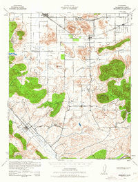
~ Murrieta CA topo map, 1:62500 scale, 15 X 15 Minute, Historical, 1942, updated 1962
Murrieta, California, USGS topographic map dated 1942.
Includes geographic coordinates (latitude and longitude). This topographic map is suitable for hiking, camping, and exploring, or framing it as a wall map.
Printed on-demand using high resolution imagery, on heavy weight and acid free paper, or alternatively on a variety of synthetic materials.
Topos available on paper, Waterproof, Poly, or Tyvek. Usually shipping rolled, unless combined with other folded maps in one order.
- Product Number: USGS-5503245
- Free digital map download (high-resolution, GeoPDF): Murrieta, California (file size: 7 MB)
- Map Size: please refer to the dimensions of the GeoPDF map above
- Weight (paper map): ca. 55 grams
- Map Type: POD USGS Topographic Map
- Map Series: HTMC
- Map Verison: Historical
- Cell ID: 58203
- Scan ID: 298335
- Imprint Year: 1962
- Woodland Tint: Yes
- Aerial Photo Year: 1939
- Datum: NAD27
- Map Projection: Polyconic
- Map published by United States Army Corps of Engineers
- Map Language: English
- Scanner Resolution: 600 dpi
- Map Cell Name: Murrienta
- Grid size: 15 X 15 Minute
- Date on map: 1942
- Map Scale: 1:62500
- Geographical region: California, United States
Neighboring Maps:
All neighboring USGS topo maps are available for sale online at a variety of scales.
Spatial coverage:
Topo map Murrieta, California, covers the geographical area associated the following places:
- Murrieta Hot Springs - Winchester - Valle de los Caballos - Valley Vista - Quail Valley - Indian Oaks - Country Road Estates - Sun City - Antelope Hills - Menifee - Green Acres - Homeland - Romoland - South Park - Linda Rose - Auld (historical) - Glenoaks Country - Menifee Lakes - Heritage Mobile Home Park - Warm Springs Mobile Home Park - Egan - Dutch Village - Murrieta - Highland Plams Mobile Home Park - High Acres Haciendas - Mission Hills Mobile Home Park
- Map Area ID: AREA33.7533.5-117.25-117
- Northwest corner Lat/Long code: USGSNW33.75-117.25
- Northeast corner Lat/Long code: USGSNE33.75-117
- Southwest corner Lat/Long code: USGSSW33.5-117.25
- Southeast corner Lat/Long code: USGSSE33.5-117
- Northern map edge Latitude: 33.75
- Southern map edge Latitude: 33.5
- Western map edge Longitude: -117.25
- Eastern map edge Longitude: -117


