
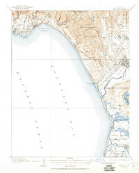
~ Capitola CA topo map, 1:62500 scale, 15 X 15 Minute, Historical, 1912, updated 1960
Capitola, California, USGS topographic map dated 1912.
Includes geographic coordinates (latitude and longitude). This topographic map is suitable for hiking, camping, and exploring, or framing it as a wall map.
Printed on-demand using high resolution imagery, on heavy weight and acid free paper, or alternatively on a variety of synthetic materials.
Topos available on paper, Waterproof, Poly, or Tyvek. Usually shipping rolled, unless combined with other folded maps in one order.
- Product Number: USGS-5500941
- Free digital map download (high-resolution, GeoPDF): Capitola, California (file size: 6 MB)
- Map Size: please refer to the dimensions of the GeoPDF map above
- Weight (paper map): ca. 55 grams
- Map Type: POD USGS Topographic Map
- Map Series: HTMC
- Map Verison: Historical
- Cell ID: 52165
- Scan ID: 297021
- Imprint Year: 1960
- Survey Year: 1912
- Datum: Unstated
- Map Projection: Unstated
- Map published by United States Geological Survey
- Map Language: English
- Scanner Resolution: 600 dpi
- Map Cell Name: Capitola
- Grid size: 15 X 15 Minute
- Date on map: 1912
- Map Scale: 1:62500
- Geographical region: California, United States
Neighboring Maps:
All neighboring USGS topo maps are available for sale online at a variety of scales.
Spatial coverage:
Topo map Capitola, California, covers the geographical area associated the following places:
- Castroville - Meadows Manor Mobile Home Park - New Brighton (historical) - Larkin Valley - Opal Cliff Park Mobile Home Park - Trailer Haven - La Selva Beach - Strongs Mobile Village - Corralitos - Twin Lakes - Brookvale Terrace Mobile Home Park - Moss Landing - Port Watsonvile - Castle Mobile Estates - Farley (historical) - Rio Del Mar - Watsonville - Snug Harbor Mobile Home Park - Seacliff - Live Oak - Tradewinds Mobile Home Park - Bell Harbor Mobile Home Park - Amesti - El Cerrito Mobile Home Park - Monterey Vista Mobile Home Park - Ocean Breeze Mobile Home Park - Aptos Hills - Portola Heights Mobile Home Park - Rob Roy Junction - Opal Cliffs - Aptos - Soquel - Monte Toyon - Cliftwood Mobile Home Park - Nuga (historical) - Country Villa Estates Mobile Home Park - Ellicott - Port Watsonville (historical) - Alimur Park Mobile Home Park - Surf and Sand Mobile Home Park - Capitola - Moss - Old Mill Park Mobile Home Park - Cabrillo Mobile Home Park - Loma Vista Mobile Home Park - Freedom - Leonard (historical) - Shangri La Estates - Tony Ziro Mobile Living Mobile Home Park - Colache Town - Orchard Lane Mobile Home Park
- Map Area ID: AREA3736.75-122-121.75
- Northwest corner Lat/Long code: USGSNW37-122
- Northeast corner Lat/Long code: USGSNE37-121.75
- Southwest corner Lat/Long code: USGSSW36.75-122
- Southeast corner Lat/Long code: USGSSE36.75-121.75
- Northern map edge Latitude: 37
- Southern map edge Latitude: 36.75
- Western map edge Longitude: -122
- Eastern map edge Longitude: -121.75


